You are here: Home > Network List > GS - US Geological Survey Networks Stations List
> Station DEC06 Boomer > Earthquake Result Viewer
DEC06 Boomer - Earthquake Result Viewer
*The percent match for this event was below the threshold and hence no stack was calculated.
| Earthquake location: |
North Atlantic Ocean |
| Earthquake latitude/longitude: |
15.5/-49.9 |
| Earthquake time(UTC): |
2018/11/17 (321) 13:17:59 GMT |
| Earthquake Depth: |
10 km |
| Earthquake Magnitude: |
5.5 Mww |
| Earthquake Catalog/Contributor: |
NEIC PDE/us |
|
| Network: |
GS US Geological Survey Networks |
| Station: |
DEC06 Boomer |
| Lat/Lon: |
39.90 N/88.95 W |
| Elevation: |
215 m |
|
| Distance: |
41.7 deg |
| Az: |
313.306 deg |
| Baz: |
114.249 deg |
| Ray Param: |
$rayparam |
*The percent match for this event was below the threshold and hence was not used in the summary stack. |
|
| Radial Match: |
59.62221 % |
| Radial Bump: |
400 |
| Transverse Match: |
54.188404 % |
| Transverse Bump: |
400 |
| SOD ConfigId: |
3165032 |
| Insert Time: |
2018-12-16 17:38:34.891 +0000 |
| GWidth: |
2.5 |
| Max Bumps: |
400 |
| Tol: |
0.001 |
|
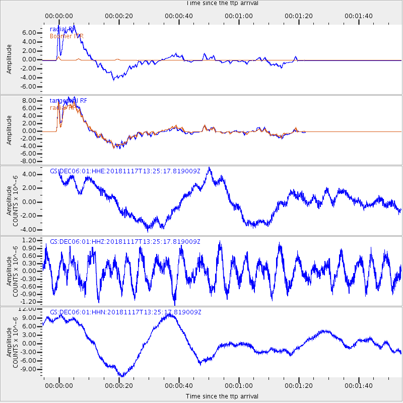
Signal To Noise
| Channel | StoN | STA | LTA |
| GS:DEC06:01:HHZ:20181117T13:25:17.819009Z | 1.0330148 | 4.6686097E-7 | 4.5194025E-7 |
| GS:DEC06:01:HHN:20181117T13:25:17.819009Z | 1.9014479 | 1.548037E-5 | 8.141358E-6 |
| GS:DEC06:01:HHE:20181117T13:25:17.819009Z | 2.550095 | 4.654011E-6 | 1.8250341E-6 |
| Arrivals |
| Ps | |
| PpPs | |
| PsPs/PpSs | |


