You are here: Home > Network List > C0 - Colorado Geological Survey Seismic Network Stations List
> Station T25A Trinidad, CO > Earthquake Result Viewer
T25A Trinidad, CO - Earthquake Result Viewer
| Earthquake location: |
Komandorskiye Ostrova Region |
| Earthquake latitude/longitude: |
54.7/168.2 |
| Earthquake time(UTC): |
2023/08/01 (213) 16:49:49 GMT |
| Earthquake Depth: |
11 km |
| Earthquake Magnitude: |
5.7 Mww |
| Earthquake Catalog/Contributor: |
NEIC PDE/us |
|
| Network: |
C0 Colorado Geological Survey Seismic Network |
| Station: |
T25A Trinidad, CO |
| Lat/Lon: |
37.08 N/104.25 W |
| Elevation: |
1800 m |
|
| Distance: |
59.4 deg |
| Az: |
68.139 deg |
| Baz: |
317.605 deg |
| Ray Param: |
0.062207915 |
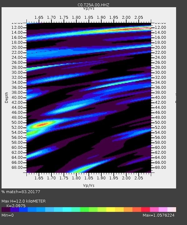
| Estimated Moho Depth: |
12.0 km |
| Estimated Crust Vp/Vs: |
2.10 |
| Assumed Crust Vp: |
6.316 km/s |
| Estimated Crust Vs: |
3.011 km/s |
| Estimated Crust Poisson's Ratio: |
0.35 |
|
| Radial Match: |
83.20177 % |
| Radial Bump: |
333 |
| Transverse Match: |
71.18756 % |
| Transverse Bump: |
400 |
| SOD ConfigId: |
31937991 |
| Insert Time: |
2023-08-15 16:55:02.747 +0000 |
| GWidth: |
2.5 |
| Max Bumps: |
400 |
| Tol: |
0.001 |
|

Signal To Noise
| Channel | StoN | STA | LTA |
| C0:T25A:00:HHZ:20230801T16:59:19.60002Z | 7.9542475 | 4.600749E-7 | 5.7840154E-8 |
| C0:T25A:00:HHN:20230801T16:59:19.60002Z | 6.595369 | 2.5825244E-7 | 3.9156635E-8 |
| C0:T25A:00:HHE:20230801T16:59:19.60002Z | 1.4619218 | 8.3962895E-8 | 5.7433233E-8 |
| Arrivals |
| Ps | 2.2 SECOND |
| PpPs | 5.7 SECOND |
| PsPs/PpSs | 7.8 SECOND |


