You are here: Home > Network List > GS - US Geological Survey Networks Stations List
> Station KAN09 Caldwell North Station > Earthquake Result Viewer
KAN09 Caldwell North Station - Earthquake Result Viewer

| Earthquake location: |
North Atlantic Ocean |
| Earthquake latitude/longitude: |
15.5/-49.9 |
| Earthquake time(UTC): |
2018/11/17 (321) 13:17:59 GMT |
| Earthquake Depth: |
10 km |
| Earthquake Magnitude: |
5.5 Mww |
| Earthquake Catalog/Contributor: |
NEIC PDE/us |
|
| Network: |
GS US Geological Survey Networks |
| Station: |
KAN09 Caldwell North Station |
| Lat/Lon: |
37.14 N/97.62 W |
| Elevation: |
371 m |
|
| Distance: |
47.3 deg |
| Az: |
306.426 deg |
| Baz: |
103.949 deg |
| Ray Param: |
0.07009212 |
| Estimated Moho Depth: |
39.5 km |
| Estimated Crust Vp/Vs: |
1.73 |
| Assumed Crust Vp: |
6.483 km/s |
| Estimated Crust Vs: |
3.742 km/s |
| Estimated Crust Poisson's Ratio: |
0.25 |
|
| Radial Match: |
83.43146 % |
| Radial Bump: |
400 |
| Transverse Match: |
68.03249 % |
| Transverse Bump: |
400 |
| SOD ConfigId: |
3165032 |
| Insert Time: |
2018-12-16 17:38:42.266 +0000 |
| GWidth: |
2.5 |
| Max Bumps: |
400 |
| Tol: |
0.001 |
|
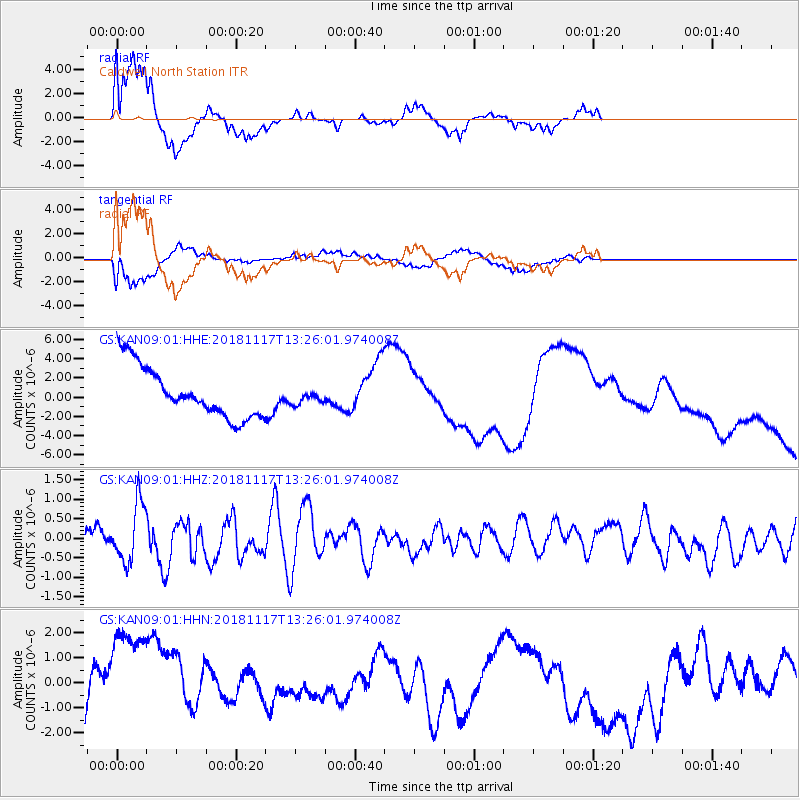
Signal To Noise
| Channel | StoN | STA | LTA |
| GS:KAN09:01:HHZ:20181117T13:26:01.974008Z | 1.6456107 | 7.4692605E-7 | 4.538899E-7 |
| GS:KAN09:01:HHN:20181117T13:26:01.974008Z | 3.2087858 | 2.6161038E-6 | 8.15294E-7 |
| GS:KAN09:01:HHE:20181117T13:26:01.974008Z | 0.30233026 | 8.02419E-7 | 2.6541143E-6 |
| Arrivals |
| Ps | 4.8 SECOND |
| PpPs | 16 SECOND |
| PsPs/PpSs | 20 SECOND |


