You are here: Home > Network List > CN - Canadian National Seismograph Network Stations List
> Station PABB Port Alberni, BC, CA > Earthquake Result Viewer
PABB Port Alberni, BC, CA - Earthquake Result Viewer
| Earthquake location: |
Komandorskiye Ostrova Region |
| Earthquake latitude/longitude: |
54.7/168.2 |
| Earthquake time(UTC): |
2023/08/01 (213) 16:49:49 GMT |
| Earthquake Depth: |
11 km |
| Earthquake Magnitude: |
5.7 Mww |
| Earthquake Catalog/Contributor: |
NEIC PDE/us |
|
| Network: |
CN Canadian National Seismograph Network |
| Station: |
PABB Port Alberni, BC, CA |
| Lat/Lon: |
49.22 N/124.81 W |
| Elevation: |
3.0 m |
|
| Distance: |
40.2 deg |
| Az: |
69.161 deg |
| Baz: |
304.098 deg |
| Ray Param: |
0.07453099 |
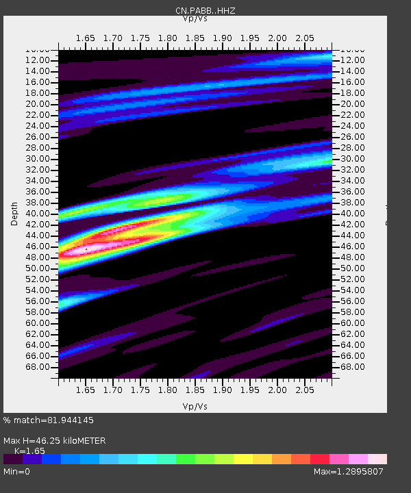
| Estimated Moho Depth: |
46.25 km |
| Estimated Crust Vp/Vs: |
1.65 |
| Assumed Crust Vp: |
6.391 km/s |
| Estimated Crust Vs: |
3.873 km/s |
| Estimated Crust Poisson's Ratio: |
0.21 |
|
| Radial Match: |
81.944145 % |
| Radial Bump: |
323 |
| Transverse Match: |
68.785034 % |
| Transverse Bump: |
400 |
| SOD ConfigId: |
31937991 |
| Insert Time: |
2023-08-15 17:00:41.025 +0000 |
| GWidth: |
2.5 |
| Max Bumps: |
400 |
| Tol: |
0.001 |
|

Signal To Noise
| Channel | StoN | STA | LTA |
| CN:PABB: :HHZ:20230801T16:56:54.669996Z | 8.527963 | 6.2416865E-7 | 7.319083E-8 |
| CN:PABB: :HHN:20230801T16:56:54.669996Z | 3.9065604 | 2.4740208E-7 | 6.33299E-8 |
| CN:PABB: :HHE:20230801T16:56:54.669996Z | 5.874377 | 2.7105557E-7 | 4.6142013E-8 |
| Arrivals |
| Ps | 5.1 SECOND |
| PpPs | 18 SECOND |
| PsPs/PpSs | 23 SECOND |


