You are here: Home > Network List > N4 - Central and EAstern US Network Stations List
> Station BGNE Belgrade, NE, USA > Earthquake Result Viewer
BGNE Belgrade, NE, USA - Earthquake Result Viewer
| Earthquake location: |
Komandorskiye Ostrova Region |
| Earthquake latitude/longitude: |
54.7/168.2 |
| Earthquake time(UTC): |
2023/08/01 (213) 16:49:49 GMT |
| Earthquake Depth: |
11 km |
| Earthquake Magnitude: |
5.7 Mww |
| Earthquake Catalog/Contributor: |
NEIC PDE/us |
|
| Network: |
N4 Central and EAstern US Network |
| Station: |
BGNE Belgrade, NE, USA |
| Lat/Lon: |
41.41 N/98.15 W |
| Elevation: |
573 m |
|
| Distance: |
59.4 deg |
| Az: |
60.698 deg |
| Baz: |
317.661 deg |
| Ray Param: |
0.062206093 |
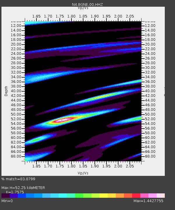
| Estimated Moho Depth: |
52.25 km |
| Estimated Crust Vp/Vs: |
1.76 |
| Assumed Crust Vp: |
6.53 km/s |
| Estimated Crust Vs: |
3.716 km/s |
| Estimated Crust Poisson's Ratio: |
0.26 |
|
| Radial Match: |
83.8799 % |
| Radial Bump: |
398 |
| Transverse Match: |
67.75966 % |
| Transverse Bump: |
400 |
| SOD ConfigId: |
31937991 |
| Insert Time: |
2023-08-15 17:09:16.563 +0000 |
| GWidth: |
2.5 |
| Max Bumps: |
400 |
| Tol: |
0.001 |
|

Signal To Noise
| Channel | StoN | STA | LTA |
| N4:BGNE:00:HHZ:20230801T16:59:20.520002Z | 7.547423 | 6.3174974E-7 | 8.370404E-8 |
| N4:BGNE:00:HH1:20230801T16:59:20.520002Z | 2.9037998 | 4.2474795E-7 | 1.4627315E-7 |
| N4:BGNE:00:HH2:20230801T16:59:20.520002Z | 2.8758929 | 3.9214876E-7 | 1.3635723E-7 |
| Arrivals |
| Ps | 6.4 SECOND |
| PpPs | 21 SECOND |
| PsPs/PpSs | 27 SECOND |


