You are here: Home > Network List > PF - Volcanologic Network of Piton de Fournaise-OVPF Stations List
> Station HIM cratere Himiltrude > Earthquake Result Viewer
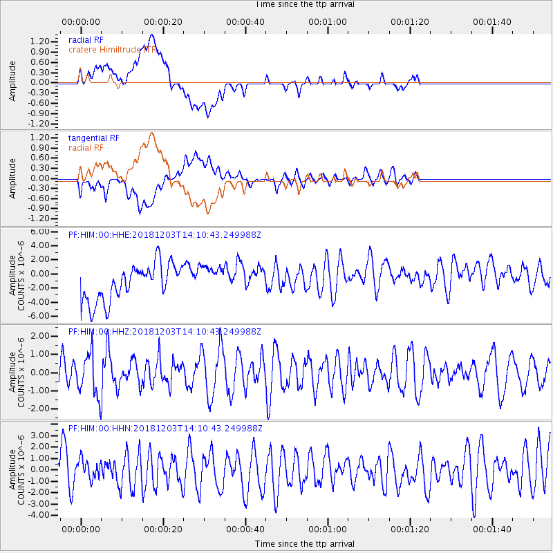
HIM cratere Himiltrude - Earthquake Result Viewer
*The percent match for this event was below the threshold and hence no stack was calculated.
| Earthquake location: |
Banda Sea |
| Earthquake latitude/longitude: |
-7.4/128.8 |
| Earthquake time(UTC): |
2018/12/03 (337) 14:00:08 GMT |
| Earthquake Depth: |
141 km |
| Earthquake Magnitude: |
5.4 Mww |
| Earthquake Catalog/Contributor: |
NEIC PDE/us |
|
| Network: |
PF Volcanologic Network of Piton de Fournaise-OVPF |
| Station: |
HIM cratere Himiltrude |
| Lat/Lon: |
21.21 S/55.72 E |
| Elevation: |
1958 m |
|
| Distance: |
71.6 deg |
| Az: |
250.161 deg |
| Baz: |
90.91 deg |
| Ray Param: |
$rayparam |
*The percent match for this event was below the threshold and hence was not used in the summary stack. |
|
| Radial Match: |
45.059456 % |
| Radial Bump: |
400 |
| Transverse Match: |
47.557564 % |
| Transverse Bump: |
400 |
| SOD ConfigId: |
3165032 |
| Insert Time: |
2018-12-17 14:13:00.807 +0000 |
| GWidth: |
2.5 |
| Max Bumps: |
400 |
| Tol: |
0.001 |
|
Signal To Noise
| Channel | StoN | STA | LTA |
| PF:HIM:00:HHZ:20181203T14:10:43.249988Z | 0.871994 | 1.1676065E-6 | 1.3390074E-6 |
| PF:HIM:00:HHN:20181203T14:10:43.249988Z | 0.48205283 | 1.1192943E-6 | 2.321933E-6 |
| PF:HIM:00:HHE:20181203T14:10:43.249988Z | 0.8094447 | 2.0789955E-6 | 2.568422E-6 |
| Arrivals |
| Ps | |
| PpPs | |
| PsPs/PpSs | |


