You are here: Home > Network List > UU - University of Utah Regional Network Stations List
> Station FSB4 FORGE surface borehole 4, UT, USA > Earthquake Result Viewer
FSB4 FORGE surface borehole 4, UT, USA - Earthquake Result Viewer
| Earthquake location: |
Komandorskiye Ostrova Region |
| Earthquake latitude/longitude: |
54.7/168.2 |
| Earthquake time(UTC): |
2023/08/01 (213) 16:49:49 GMT |
| Earthquake Depth: |
11 km |
| Earthquake Magnitude: |
5.7 Mww |
| Earthquake Catalog/Contributor: |
NEIC PDE/us |
|
| Network: |
UU University of Utah Regional Network |
| Station: |
FSB4 FORGE surface borehole 4, UT, USA |
| Lat/Lon: |
38.43 N/112.93 W |
| Elevation: |
1578 m |
|
| Distance: |
53.7 deg |
| Az: |
72.994 deg |
| Baz: |
314.982 deg |
| Ray Param: |
0.06594251 |
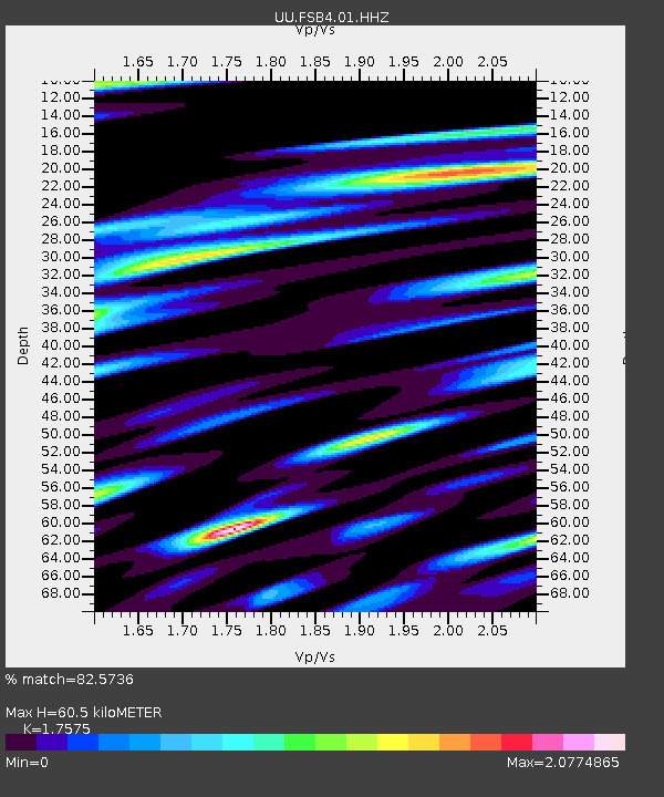
| Estimated Moho Depth: |
60.5 km |
| Estimated Crust Vp/Vs: |
1.76 |
| Assumed Crust Vp: |
6.276 km/s |
| Estimated Crust Vs: |
3.571 km/s |
| Estimated Crust Poisson's Ratio: |
0.26 |
|
| Radial Match: |
82.5736 % |
| Radial Bump: |
353 |
| Transverse Match: |
65.86503 % |
| Transverse Bump: |
392 |
| SOD ConfigId: |
31937991 |
| Insert Time: |
2023-08-15 17:26:06.098 +0000 |
| GWidth: |
2.5 |
| Max Bumps: |
400 |
| Tol: |
0.001 |
|

Signal To Noise
| Channel | StoN | STA | LTA |
| UU:FSB4:01:HHZ:20230801T16:58:39.814985Z | 6.2465496 | 5.228365E-7 | 8.3700044E-8 |
| UU:FSB4:01:HH1:20230801T16:58:39.814985Z | 1.1338236 | 1.3745395E-7 | 1.2123046E-7 |
| UU:FSB4:01:HH2:20230801T16:58:39.814985Z | 4.8341765 | 4.5897355E-7 | 9.494349E-8 |
| Arrivals |
| Ps | 7.7 SECOND |
| PpPs | 25 SECOND |
| PsPs/PpSs | 33 SECOND |


