You are here: Home > Network List > TA - USArray Transportable Network (new EarthScope stations) Stations List
> Station H17A Grant Village (NPS), Yellowstone Nt. Park, WY, USA > Earthquake Result Viewer
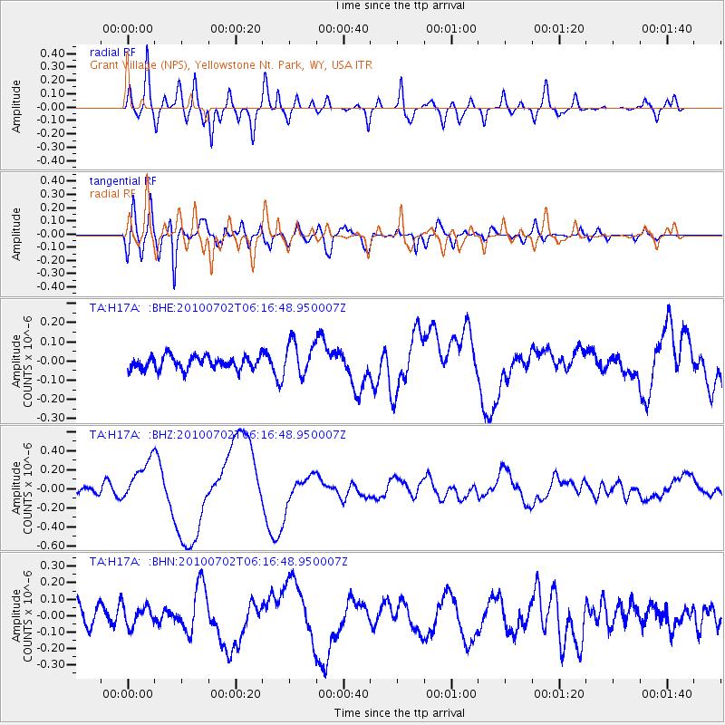
H17A Grant Village (NPS), Yellowstone Nt. Park, WY, USA - Earthquake Result Viewer
*The percent match for this event was below the threshold and hence no stack was calculated.
| Earthquake location: |
Vanuatu Islands |
| Earthquake latitude/longitude: |
-13.6/166.5 |
| Earthquake time(UTC): |
2010/07/02 (183) 06:04:03 GMT |
| Earthquake Depth: |
29 km |
| Earthquake Magnitude: |
5.8 MB, 6.2 MS, 6.3 MW, 6.3 MW |
| Earthquake Catalog/Contributor: |
WHDF/NEIC |
|
| Network: |
TA USArray Transportable Network (new EarthScope stations) |
| Station: |
H17A Grant Village (NPS), Yellowstone Nt. Park, WY, USA |
| Lat/Lon: |
44.40 N/110.58 W |
| Elevation: |
2400 m |
|
| Distance: |
94.5 deg |
| Az: |
45.529 deg |
| Baz: |
255.398 deg |
| Ray Param: |
$rayparam |
*The percent match for this event was below the threshold and hence was not used in the summary stack. |
|
| Radial Match: |
84.45578 % |
| Radial Bump: |
400 |
| Transverse Match: |
78.29984 % |
| Transverse Bump: |
400 |
| SOD ConfigId: |
319893 |
| Insert Time: |
2011-01-04 23:33:25.979 +0000 |
| GWidth: |
2.5 |
| Max Bumps: |
400 |
| Tol: |
0.001 |
|
Signal To Noise
| Channel | StoN | STA | LTA |
| TA:H17A: :BHZ:20100702T06:16:48.950007Z | 5.7609754 | 2.2015391E-7 | 3.8214694E-8 |
| TA:H17A: :BHN:20100702T06:16:48.950007Z | 0.9759632 | 6.364824E-8 | 6.521582E-8 |
| TA:H17A: :BHE:20100702T06:16:48.950007Z | 2.6114352 | 8.8566644E-8 | 3.3914933E-8 |
| Arrivals |
| Ps | |
| PpPs | |
| PsPs/PpSs | |


