You are here: Home > Network List > UW - Pacific Northwest Regional Seismic Network Stations List
> Station EDM East Dome, Mt. St. Helens, WA, USA > Earthquake Result Viewer
EDM East Dome, Mt. St. Helens, WA, USA - Earthquake Result Viewer
| Earthquake location: |
Komandorskiye Ostrova Region |
| Earthquake latitude/longitude: |
54.7/168.2 |
| Earthquake time(UTC): |
2023/08/01 (213) 16:49:49 GMT |
| Earthquake Depth: |
11 km |
| Earthquake Magnitude: |
5.7 Mww |
| Earthquake Catalog/Contributor: |
NEIC PDE/us |
|
| Network: |
UW Pacific Northwest Regional Seismic Network |
| Station: |
EDM East Dome, Mt. St. Helens, WA, USA |
| Lat/Lon: |
46.20 N/122.15 W |
| Elevation: |
1609 m |
|
| Distance: |
43.4 deg |
| Az: |
71.256 deg |
| Baz: |
307.623 deg |
| Ray Param: |
0.07255506 |
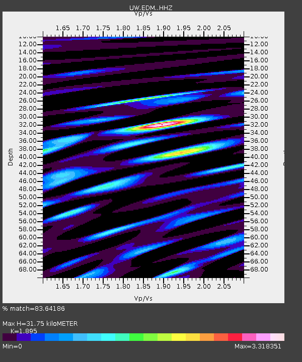
| Estimated Moho Depth: |
31.75 km |
| Estimated Crust Vp/Vs: |
1.89 |
| Assumed Crust Vp: |
6.566 km/s |
| Estimated Crust Vs: |
3.465 km/s |
| Estimated Crust Poisson's Ratio: |
0.31 |
|
| Radial Match: |
83.64186 % |
| Radial Bump: |
400 |
| Transverse Match: |
78.0707 % |
| Transverse Bump: |
400 |
| SOD ConfigId: |
31937991 |
| Insert Time: |
2023-08-15 17:27:20.700 +0000 |
| GWidth: |
2.5 |
| Max Bumps: |
400 |
| Tol: |
0.001 |
|

Signal To Noise
| Channel | StoN | STA | LTA |
| UW:EDM: :HHZ:20230801T16:57:21.030012Z | 7.5280366 | 8.557568E-7 | 1.1367596E-7 |
| UW:EDM: :HHN:20230801T16:57:21.030012Z | 2.077997 | 4.4443428E-7 | 2.1387629E-7 |
| UW:EDM: :HHE:20230801T16:57:21.030012Z | 2.2616618 | 4.3093647E-7 | 1.9053975E-7 |
| Arrivals |
| Ps | 4.6 SECOND |
| PpPs | 13 SECOND |
| PsPs/PpSs | 18 SECOND |


