You are here: Home > Network List > UW - Pacific Northwest Regional Seismic Network Stations List
> Station LUMI Lummi Island, WA > Earthquake Result Viewer
LUMI Lummi Island, WA - Earthquake Result Viewer
| Earthquake location: |
Komandorskiye Ostrova Region |
| Earthquake latitude/longitude: |
54.7/168.2 |
| Earthquake time(UTC): |
2023/08/01 (213) 16:49:49 GMT |
| Earthquake Depth: |
11 km |
| Earthquake Magnitude: |
5.7 Mww |
| Earthquake Catalog/Contributor: |
NEIC PDE/us |
|
| Network: |
UW Pacific Northwest Regional Seismic Network |
| Station: |
LUMI Lummi Island, WA |
| Lat/Lon: |
48.72 N/122.71 W |
| Elevation: |
19 m |
|
| Distance: |
41.6 deg |
| Az: |
68.582 deg |
| Baz: |
305.245 deg |
| Ray Param: |
0.07366908 |
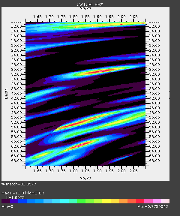
| Estimated Moho Depth: |
11.0 km |
| Estimated Crust Vp/Vs: |
2.00 |
| Assumed Crust Vp: |
6.566 km/s |
| Estimated Crust Vs: |
3.287 km/s |
| Estimated Crust Poisson's Ratio: |
0.33 |
|
| Radial Match: |
81.8577 % |
| Radial Bump: |
400 |
| Transverse Match: |
67.85102 % |
| Transverse Bump: |
400 |
| SOD ConfigId: |
31937991 |
| Insert Time: |
2023-08-15 17:28:24.452 +0000 |
| GWidth: |
2.5 |
| Max Bumps: |
400 |
| Tol: |
0.001 |
|

Signal To Noise
| Channel | StoN | STA | LTA |
| UW:LUMI: :HHZ:20230801T16:57:06.389998Z | 10.125774 | 6.975665E-7 | 6.8890195E-8 |
| UW:LUMI: :HHN:20230801T16:57:06.389998Z | 3.443374 | 3.0712727E-7 | 8.9193705E-8 |
| UW:LUMI: :HHE:20230801T16:57:06.389998Z | 2.5558784 | 2.2315066E-7 | 8.730879E-8 |
| Arrivals |
| Ps | 1.8 SECOND |
| PpPs | 4.7 SECOND |
| PsPs/PpSs | 6.5 SECOND |


