You are here: Home > Network List > TA - USArray Transportable Network (new EarthScope stations) Stations List
> Station A21A Bergtoll Ranch, Theony, MT, USA > Earthquake Result Viewer
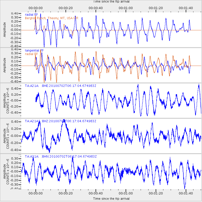
A21A Bergtoll Ranch, Theony, MT, USA - Earthquake Result Viewer
*The percent match for this event was below the threshold and hence no stack was calculated.
| Earthquake location: |
Vanuatu Islands |
| Earthquake latitude/longitude: |
-13.6/166.5 |
| Earthquake time(UTC): |
2010/07/02 (183) 06:04:03 GMT |
| Earthquake Depth: |
29 km |
| Earthquake Magnitude: |
5.8 MB, 6.2 MS, 6.3 MW, 6.3 MW |
| Earthquake Catalog/Contributor: |
WHDF/NEIC |
|
| Network: |
TA USArray Transportable Network (new EarthScope stations) |
| Station: |
A21A Bergtoll Ranch, Theony, MT, USA |
| Lat/Lon: |
48.99 N/106.93 W |
| Elevation: |
779 m |
|
| Distance: |
97.9 deg |
| Az: |
41.597 deg |
| Baz: |
258.474 deg |
| Ray Param: |
$rayparam |
*The percent match for this event was below the threshold and hence was not used in the summary stack. |
|
| Radial Match: |
62.072113 % |
| Radial Bump: |
345 |
| Transverse Match: |
45.513046 % |
| Transverse Bump: |
270 |
| SOD ConfigId: |
319893 |
| Insert Time: |
2011-01-04 23:36:02.325 +0000 |
| GWidth: |
2.5 |
| Max Bumps: |
400 |
| Tol: |
0.001 |
|
Signal To Noise
| Channel | StoN | STA | LTA |
| TA:A21A: :BHZ:20100702T06:17:04.674983Z | 3.4061902 | 2.5214888E-7 | 7.4026666E-8 |
| TA:A21A: :BHN:20100702T06:17:04.674983Z | 0.75318885 | 1.5201505E-7 | 2.018286E-7 |
| TA:A21A: :BHE:20100702T06:17:04.674983Z | 1.1044397 | 2.0804654E-7 | 1.8837294E-7 |
| Arrivals |
| Ps | |
| PpPs | |
| PsPs/PpSs | |


