You are here: Home > Network List > TA - USArray Transportable Network (new EarthScope stations) Stations List
> Station N02D Trinity Center, CA, USA > Earthquake Result Viewer
N02D Trinity Center, CA, USA - Earthquake Result Viewer

| Earthquake location: |
Vanuatu Islands |
| Earthquake latitude/longitude: |
-13.6/166.5 |
| Earthquake time(UTC): |
2010/07/02 (183) 06:04:03 GMT |
| Earthquake Depth: |
29 km |
| Earthquake Magnitude: |
5.8 MB, 6.2 MS, 6.3 MW, 6.3 MW |
| Earthquake Catalog/Contributor: |
WHDF/NEIC |
|
| Network: |
TA USArray Transportable Network (new EarthScope stations) |
| Station: |
N02D Trinity Center, CA, USA |
| Lat/Lon: |
40.97 N/122.71 W |
| Elevation: |
937 m |
|
| Distance: |
84.9 deg |
| Az: |
45.885 deg |
| Baz: |
247.187 deg |
| Ray Param: |
0.04511387 |
| Estimated Moho Depth: |
21.25 km |
| Estimated Crust Vp/Vs: |
1.92 |
| Assumed Crust Vp: |
6.566 km/s |
| Estimated Crust Vs: |
3.424 km/s |
| Estimated Crust Poisson's Ratio: |
0.31 |
|
| Radial Match: |
88.54224 % |
| Radial Bump: |
400 |
| Transverse Match: |
79.6181 % |
| Transverse Bump: |
400 |
| SOD ConfigId: |
319893 |
| Insert Time: |
2011-01-04 23:37:14.394 +0000 |
| GWidth: |
2.5 |
| Max Bumps: |
400 |
| Tol: |
0.001 |
|
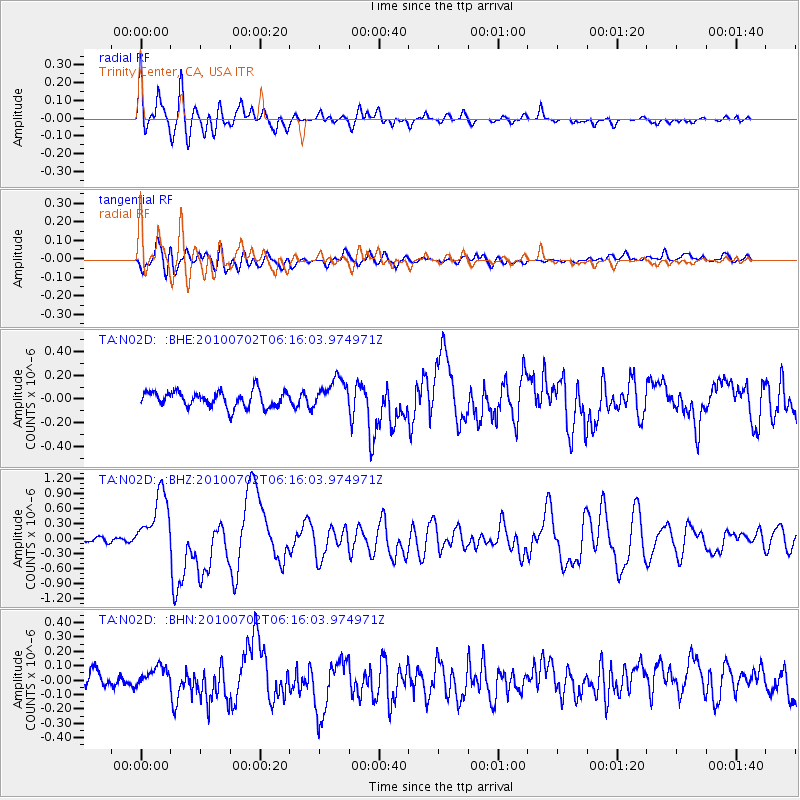
Signal To Noise
| Channel | StoN | STA | LTA |
| TA:N02D: :BHZ:20100702T06:16:03.974971Z | 12.090385 | 6.2986766E-7 | 5.2096574E-8 |
| TA:N02D: :BHN:20100702T06:16:03.974971Z | 1.1107354 | 7.083662E-8 | 6.377452E-8 |
| TA:N02D: :BHE:20100702T06:16:03.974971Z | 1.8531501 | 1.244345E-7 | 6.714755E-8 |
| Arrivals |
| Ps | 3.0 SECOND |
| PpPs | 9.2 SECOND |
| PsPs/PpSs | 12 SECOND |


