You are here: Home > Network List > IW - Intermountain West Stations List
> Station MOOW Moose Ponds, Wyoming, USA > Earthquake Result Viewer
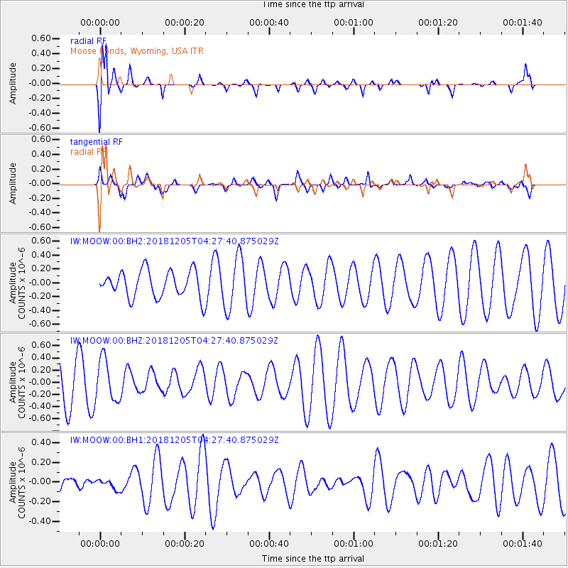
MOOW Moose Ponds, Wyoming, USA - Earthquake Result Viewer
*The percent match for this event was below the threshold and hence no stack was calculated.
| Earthquake location: |
Southeast Of Loyalty Islands |
| Earthquake latitude/longitude: |
-22.0/169.3 |
| Earthquake time(UTC): |
2018/12/05 (339) 04:14:36 GMT |
| Earthquake Depth: |
10 km |
| Earthquake Magnitude: |
6.0 mb |
| Earthquake Catalog/Contributor: |
NEIC PDE/us |
|
| Network: |
IW Intermountain West |
| Station: |
MOOW Moose Ponds, Wyoming, USA |
| Lat/Lon: |
43.75 N/110.74 W |
| Elevation: |
2128 m |
|
| Distance: |
98.0 deg |
| Az: |
46.099 deg |
| Baz: |
247.347 deg |
| Ray Param: |
$rayparam |
*The percent match for this event was below the threshold and hence was not used in the summary stack. |
|
| Radial Match: |
73.53202 % |
| Radial Bump: |
400 |
| Transverse Match: |
49.750996 % |
| Transverse Bump: |
400 |
| SOD ConfigId: |
3201911 |
| Insert Time: |
2018-12-19 04:22:09.327 +0000 |
| GWidth: |
2.5 |
| Max Bumps: |
400 |
| Tol: |
0.001 |
|
Signal To Noise
| Channel | StoN | STA | LTA |
| IW:MOOW:00:BHZ:20181205T04:27:40.875029Z | 1.0796064 | 3.4072153E-7 | 3.155979E-7 |
| IW:MOOW:00:BH1:20181205T04:27:40.875029Z | 0.43947178 | 5.014298E-8 | 1.1409829E-7 |
| IW:MOOW:00:BH2:20181205T04:27:40.875029Z | 1.960364 | 3.7679553E-7 | 1.9220693E-7 |
| Arrivals |
| Ps | |
| PpPs | |
| PsPs/PpSs | |


