You are here: Home > Network List > AV - Alaska Volcano Observatory Stations List
> Station KARR Katmai Rainbow River, Alaska > Earthquake Result Viewer
KARR Katmai Rainbow River, Alaska - Earthquake Result Viewer

| Earthquake location: |
Fiji Islands Region |
| Earthquake latitude/longitude: |
-21.6/-179.3 |
| Earthquake time(UTC): |
2023/08/02 (214) 01:32:35 GMT |
| Earthquake Depth: |
632 km |
| Earthquake Magnitude: |
5.8 mww |
| Earthquake Catalog/Contributor: |
NEIC PDE/us |
|
| Network: |
AV Alaska Volcano Observatory |
| Station: |
KARR Katmai Rainbow River, Alaska |
| Lat/Lon: |
58.50 N/154.71 W |
| Elevation: |
610 m |
|
| Distance: |
82.4 deg |
| Az: |
12.717 deg |
| Baz: |
202.964 deg |
| Ray Param: |
0.04501414 |
| Estimated Moho Depth: |
13.0 km |
| Estimated Crust Vp/Vs: |
1.80 |
| Assumed Crust Vp: |
6.438 km/s |
| Estimated Crust Vs: |
3.577 km/s |
| Estimated Crust Poisson's Ratio: |
0.28 |
|
| Radial Match: |
84.956024 % |
| Radial Bump: |
400 |
| Transverse Match: |
90.67881 % |
| Transverse Bump: |
400 |
| SOD ConfigId: |
31937991 |
| Insert Time: |
2023-08-16 01:41:09.484 +0000 |
| GWidth: |
2.5 |
| Max Bumps: |
400 |
| Tol: |
0.001 |
|
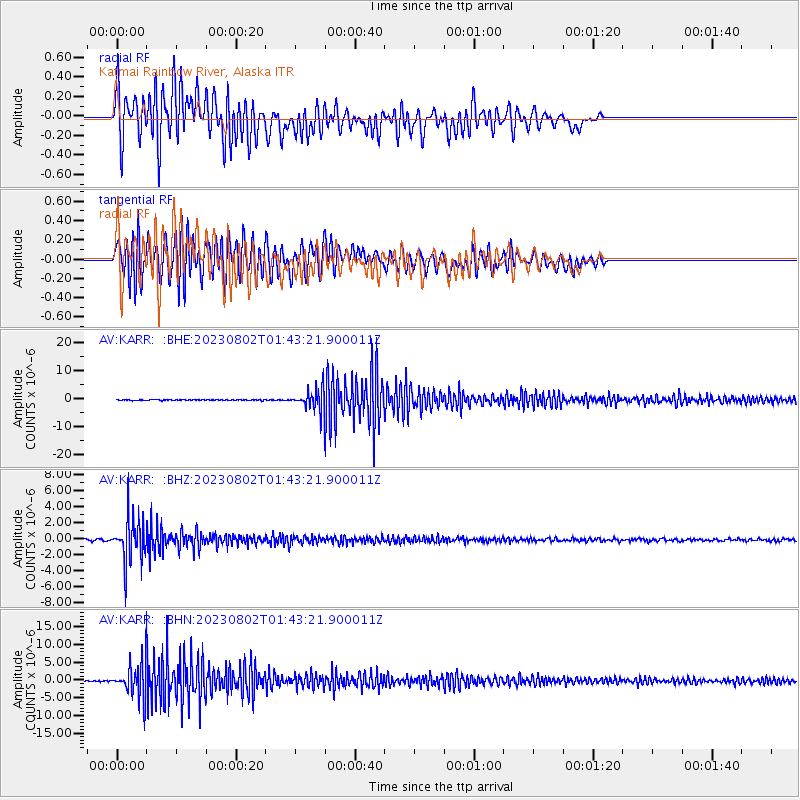
Signal To Noise
| Channel | StoN | STA | LTA |
| AV:KARR: :BHZ:20230802T01:43:21.900011Z | 33.33454 | 2.712263E-6 | 8.1364945E-8 |
| AV:KARR: :BHN:20230802T01:43:21.900011Z | 29.536974 | 4.378517E-6 | 1.4823851E-7 |
| AV:KARR: :BHE:20230802T01:43:21.900011Z | 26.03715 | 3.576943E-6 | 1.3737845E-7 |
| Arrivals |
| Ps | 1.7 SECOND |
| PpPs | 5.5 SECOND |
| PsPs/PpSs | 7.2 SECOND |


