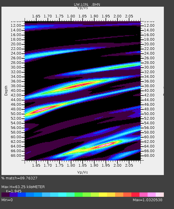
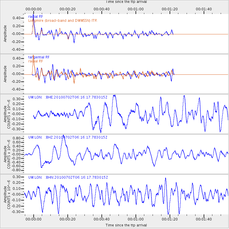
LON Longmire (broad-band and DWWSSN) - Earthquake Result Viewer

Earthquake location: Vanuatu Islands
Earthquake latitude/longitude: -13.6/166.5
Earthquake time(UTC): 2010/07/02 (183) 06:04:03 GMT
Earthquake Depth: 29 km
Earthquake Magnitude: 5.8 MB, 6.2 MS, 6.3 MW, 6.3 MW
Earthquake Catalog/Contributor: WHDF/NEIC
Network: UW Pacific Northwest Regional Seismic Network
Station: LON Longmire (broad-band and DWWSSN)
Lat/Lon: 46.75 N/121.81 W
Elevation: 850 m
Distance: 87.7 deg
Az: 40.797 deg
Baz: 247.478 deg
Ray Param: 0.043080177
Estimated Moho Depth: 63.25 km
Estimated Crust Vp/Vs: 1.95
Assumed Crust Vp: 6.597 km/s
Estimated Crust Vs: 3.392 km/s
Estimated Crust Poisson's Ratio: 0.32
Radial Match: 89.76327 %
Radial Bump: 400
Transverse Match: 75.07562 %
Transverse Bump: 400
SOD ConfigId: 319893
Insert Time: 2011-01-04 23:40:12.683 +0000
GWidth: 2.5
Max Bumps: 400
Tol: 0.001

Signal To Noise

ChannelStoNSTALTA
UW:LON: :BHZ:20100702T06:16:17.783015Z6.19632433.5439254E-75.7193994E-8
UW:LON: :BHN:20100702T06:16:17.783015Z1.93966078.6548575E-84.4620474E-8
UW:LON: :BHE:20100702T06:16:17.783015Z4.26550771.4812856E-73.4727066E-8
Arrivals
Ps9.3 SECOND
PpPs28 SECOND
PsPs/PpSs37 SECOND