You are here: Home > Network List > AV - Alaska Volcano Observatory Stations List
> Station R17L Mt. Peulik Volcano, AVO PLK4, AK, USA > Earthquake Result Viewer
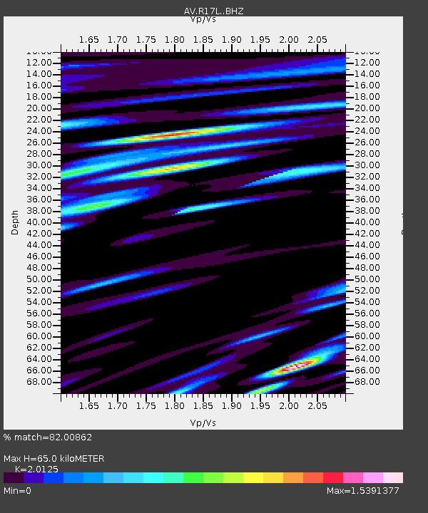
R17L Mt. Peulik Volcano, AVO PLK4, AK, USA - Earthquake Result Viewer
| Earthquake location: |
Fiji Islands Region |
| Earthquake latitude/longitude: |
-21.6/-179.3 |
| Earthquake time(UTC): |
2023/08/02 (214) 01:32:35 GMT |
| Earthquake Depth: |
632 km |
| Earthquake Magnitude: |
5.8 mww |
| Earthquake Catalog/Contributor: |
NEIC PDE/us |
|
| Network: |
AV Alaska Volcano Observatory |
| Station: |
R17L Mt. Peulik Volcano, AVO PLK4, AK, USA |
| Lat/Lon: |
57.63 N/156.36 W |
| Elevation: |
524 m |
|
| Distance: |
81.2 deg |
| Az: |
12.227 deg |
| Baz: |
201.493 deg |
| Ray Param: |
0.045777444 |
| Estimated Moho Depth: |
65.0 km |
| Estimated Crust Vp/Vs: |
2.01 |
| Assumed Crust Vp: |
6.1 km/s |
| Estimated Crust Vs: |
3.031 km/s |
| Estimated Crust Poisson's Ratio: |
0.34 |
|
| Radial Match: |
82.00862 % |
| Radial Bump: |
400 |
| Transverse Match: |
77.93604 % |
| Transverse Bump: |
400 |
| SOD ConfigId: |
31937991 |
| Insert Time: |
2023-08-16 01:42:26.438 +0000 |
| GWidth: |
2.5 |
| Max Bumps: |
400 |
| Tol: |
0.001 |
|

Signal To Noise
| Channel | StoN | STA | LTA |
| AV:R17L: :BHZ:20230802T01:43:16.174974Z | 25.283985 | 1.7139861E-6 | 6.7789394E-8 |
| AV:R17L: :BHN:20230802T01:43:16.174974Z | 15.667156 | 9.4973234E-7 | 6.061932E-8 |
| AV:R17L: :BHE:20230802T01:43:16.174974Z | 11.356467 | 5.9813965E-7 | 5.2669517E-8 |
| Arrivals |
| Ps | 11 SECOND |
| PpPs | 31 SECOND |
| PsPs/PpSs | 42 SECOND |


