You are here: Home > Network List > UW - Pacific Northwest Regional Seismic Network Stations List
> Station TUCA Wood Farm, Starbuck, WA, USA > Earthquake Result Viewer
TUCA Wood Farm, Starbuck, WA, USA - Earthquake Result Viewer
| Earthquake location: |
Vanuatu Islands |
| Earthquake latitude/longitude: |
-13.6/166.5 |
| Earthquake time(UTC): |
2010/07/02 (183) 06:04:03 GMT |
| Earthquake Depth: |
29 km |
| Earthquake Magnitude: |
5.8 MB, 6.2 MS, 6.3 MW, 6.3 MW |
| Earthquake Catalog/Contributor: |
WHDF/NEIC |
|
| Network: |
UW Pacific Northwest Regional Seismic Network |
| Station: |
TUCA Wood Farm, Starbuck, WA, USA |
| Lat/Lon: |
46.51 N/118.15 W |
| Elevation: |
304 m |
|
| Distance: |
90.0 deg |
| Az: |
41.929 deg |
| Baz: |
250.156 deg |
| Ray Param: |
0.041701645 |
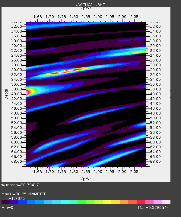
| Estimated Moho Depth: |
30.25 km |
| Estimated Crust Vp/Vs: |
1.77 |
| Assumed Crust Vp: |
6.419 km/s |
| Estimated Crust Vs: |
3.632 km/s |
| Estimated Crust Poisson's Ratio: |
0.26 |
|
| Radial Match: |
90.79417 % |
| Radial Bump: |
400 |
| Transverse Match: |
64.953575 % |
| Transverse Bump: |
400 |
| SOD ConfigId: |
319893 |
| Insert Time: |
2011-01-04 23:41:08.568 +0000 |
| GWidth: |
2.5 |
| Max Bumps: |
400 |
| Tol: |
0.001 |
|

Signal To Noise
| Channel | StoN | STA | LTA |
| UW:TUCA: :BHZ:20100702T06:16:28.450007Z | 8.612087 | 4.6871824E-7 | 5.442563E-8 |
| UW:TUCA: :BHN:20100702T06:16:28.450007Z | 1.5663185 | 9.774835E-8 | 6.240643E-8 |
| UW:TUCA: :BHE:20100702T06:16:28.450007Z | 5.6456623 | 1.4911876E-7 | 2.6412978E-8 |
| Arrivals |
| Ps | 3.7 SECOND |
| PpPs | 13 SECOND |
| PsPs/PpSs | 16 SECOND |


