You are here: Home > Network List > G - GEOSCOPE Stations List
> Station CRZF Port Alfred, Crozet, South Indian Ocean > Earthquake Result Viewer
CRZF Port Alfred, Crozet, South Indian Ocean - Earthquake Result Viewer
| Earthquake location: |
Southeast Of Loyalty Islands |
| Earthquake latitude/longitude: |
-22.0/169.4 |
| Earthquake time(UTC): |
2018/12/05 (339) 04:18:08 GMT |
| Earthquake Depth: |
10 km |
| Earthquake Magnitude: |
7.5 Mww |
| Earthquake Catalog/Contributor: |
NEIC PDE/us |
|
| Network: |
G GEOSCOPE |
| Station: |
CRZF Port Alfred, Crozet, South Indian Ocean |
| Lat/Lon: |
46.43 S/51.86 E |
| Elevation: |
140 m |
|
| Distance: |
91.6 deg |
| Az: |
217.828 deg |
| Baz: |
124.606 deg |
| Ray Param: |
0.041578516 |
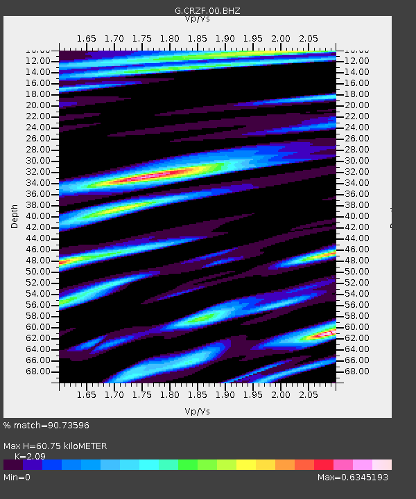
| Estimated Moho Depth: |
60.75 km |
| Estimated Crust Vp/Vs: |
2.09 |
| Assumed Crust Vp: |
4.802 km/s |
| Estimated Crust Vs: |
2.298 km/s |
| Estimated Crust Poisson's Ratio: |
0.35 |
|
| Radial Match: |
90.73596 % |
| Radial Bump: |
400 |
| Transverse Match: |
75.050606 % |
| Transverse Bump: |
400 |
| SOD ConfigId: |
3201911 |
| Insert Time: |
2018-12-19 04:24:13.509 +0000 |
| GWidth: |
2.5 |
| Max Bumps: |
400 |
| Tol: |
0.001 |
|
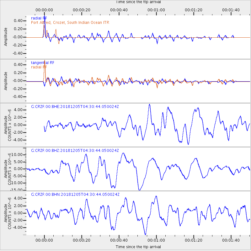
Signal To Noise
| Channel | StoN | STA | LTA |
| G:CRZF:00:BHZ:20181205T04:30:44.050024Z | 3.9147763 | 2.027185E-6 | 5.178291E-7 |
| G:CRZF:00:BHN:20181205T04:30:44.050024Z | 1.4698671 | 8.933282E-7 | 6.077612E-7 |
| G:CRZF:00:BHE:20181205T04:30:44.050024Z | 1.8683329 | 1.0239307E-6 | 5.4804514E-7 |
| Arrivals |
| Ps | 14 SECOND |
| PpPs | 39 SECOND |
| PsPs/PpSs | 53 SECOND |


