You are here: Home > Network List > II - Global Seismograph Network (GSN - IRIS/IDA) Stations List
> Station COCO West Island, Cocos (Keeling) Islands > Earthquake Result Viewer
COCO West Island, Cocos (Keeling) Islands - Earthquake Result Viewer
| Earthquake location: |
Southeast Of Loyalty Islands |
| Earthquake latitude/longitude: |
-22.0/169.4 |
| Earthquake time(UTC): |
2018/12/05 (339) 04:18:08 GMT |
| Earthquake Depth: |
10 km |
| Earthquake Magnitude: |
7.5 Mww |
| Earthquake Catalog/Contributor: |
NEIC PDE/us |
|
| Network: |
II Global Seismograph Network (GSN - IRIS/IDA) |
| Station: |
COCO West Island, Cocos (Keeling) Islands |
| Lat/Lon: |
12.19 S/96.83 E |
| Elevation: |
1.0 m |
|
| Distance: |
69.6 deg |
| Az: |
264.73 deg |
| Baz: |
109.026 deg |
| Ray Param: |
0.05556838 |
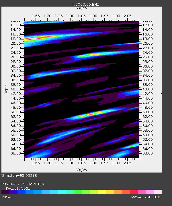
| Estimated Moho Depth: |
17.75 km |
| Estimated Crust Vp/Vs: |
1.62 |
| Assumed Crust Vp: |
4.24 km/s |
| Estimated Crust Vs: |
2.621 km/s |
| Estimated Crust Poisson's Ratio: |
0.19 |
|
| Radial Match: |
95.03218 % |
| Radial Bump: |
400 |
| Transverse Match: |
91.64528 % |
| Transverse Bump: |
382 |
| SOD ConfigId: |
3201911 |
| Insert Time: |
2018-12-19 04:24:36.851 +0000 |
| GWidth: |
2.5 |
| Max Bumps: |
400 |
| Tol: |
0.001 |
|
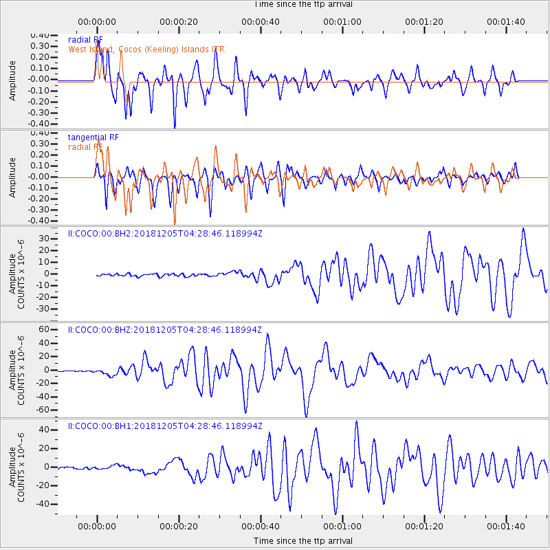
Signal To Noise
| Channel | StoN | STA | LTA |
| II:COCO:00:BHZ:20181205T04:28:46.118994Z | 8.921874 | 5.0725407E-6 | 5.6855106E-7 |
| II:COCO:00:BH1:20181205T04:28:46.118994Z | 2.2291713 | 2.1902408E-6 | 9.82536E-7 |
| II:COCO:00:BH2:20181205T04:28:46.118994Z | 2.1740377 | 2.30116E-6 | 1.0584729E-6 |
| Arrivals |
| Ps | 2.6 SECOND |
| PpPs | 11 SECOND |
| PsPs/PpSs | 13 SECOND |


