You are here: Home > Network List > IU - Global Seismograph Network (GSN - IRIS/USGS) Stations List
> Station COR Corvallis, Oregon, USA > Earthquake Result Viewer
COR Corvallis, Oregon, USA - Earthquake Result Viewer
| Earthquake location: |
Southeast Of Loyalty Islands |
| Earthquake latitude/longitude: |
-22.0/169.4 |
| Earthquake time(UTC): |
2018/12/05 (339) 04:18:08 GMT |
| Earthquake Depth: |
10 km |
| Earthquake Magnitude: |
7.5 Mww |
| Earthquake Catalog/Contributor: |
NEIC PDE/us |
|
| Network: |
IU Global Seismograph Network (GSN - IRIS/USGS) |
| Station: |
COR Corvallis, Oregon, USA |
| Lat/Lon: |
44.59 N/123.30 W |
| Elevation: |
110 m |
|
| Distance: |
90.2 deg |
| Az: |
41.221 deg |
| Baz: |
238.875 deg |
| Ray Param: |
0.041689545 |
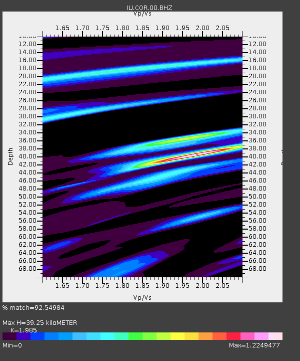
| Estimated Moho Depth: |
39.25 km |
| Estimated Crust Vp/Vs: |
1.99 |
| Assumed Crust Vp: |
6.566 km/s |
| Estimated Crust Vs: |
3.308 km/s |
| Estimated Crust Poisson's Ratio: |
0.33 |
|
| Radial Match: |
92.54984 % |
| Radial Bump: |
400 |
| Transverse Match: |
82.469604 % |
| Transverse Bump: |
400 |
| SOD ConfigId: |
3201911 |
| Insert Time: |
2018-12-19 04:24:49.506 +0000 |
| GWidth: |
2.5 |
| Max Bumps: |
400 |
| Tol: |
0.001 |
|
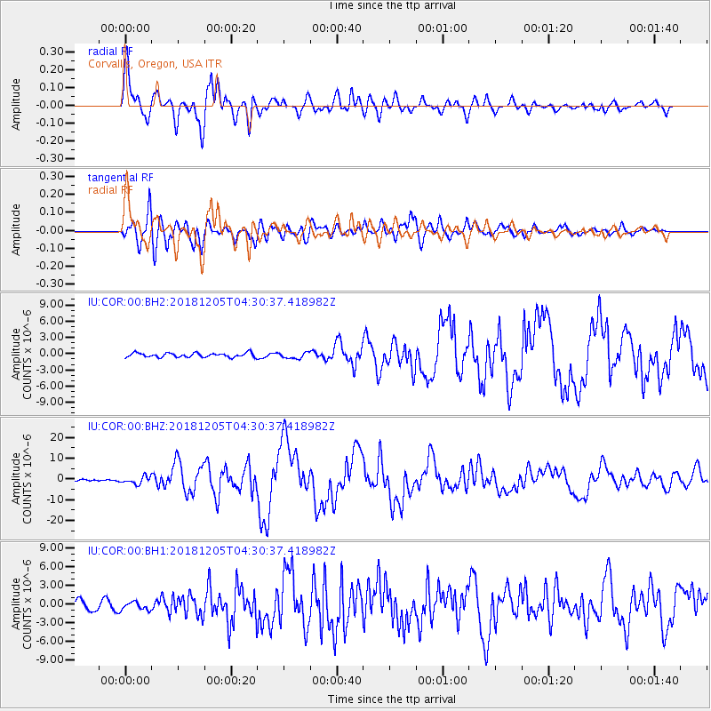
Signal To Noise
| Channel | StoN | STA | LTA |
| IU:COR:00:BHZ:20181205T04:30:37.418982Z | 5.238892 | 1.7455351E-6 | 3.331878E-7 |
| IU:COR:00:BH1:20181205T04:30:37.418982Z | 1.0448905 | 6.147981E-7 | 5.883852E-7 |
| IU:COR:00:BH2:20181205T04:30:37.418982Z | 1.4375217 | 5.5021997E-7 | 3.8275596E-7 |
| Arrivals |
| Ps | 6.0 SECOND |
| PpPs | 18 SECOND |
| PsPs/PpSs | 24 SECOND |


