You are here: Home > Network List > TA - USArray Transportable Network (new EarthScope stations) Stations List
> Station S29A Ulysses, KS, USA > Earthquake Result Viewer
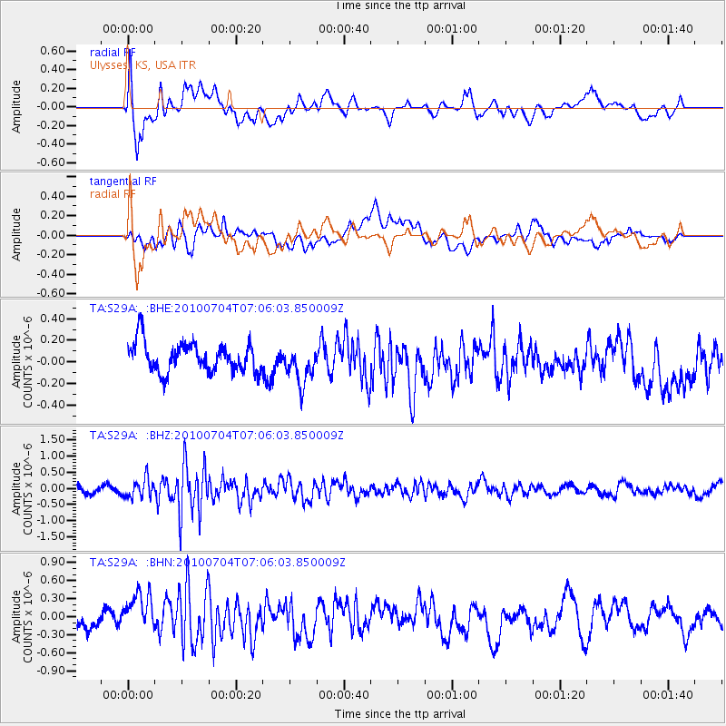
S29A Ulysses, KS, USA - Earthquake Result Viewer
*The percent match for this event was below the threshold and hence no stack was calculated.
| Earthquake location: |
Off Coast Of Northern Peru |
| Earthquake latitude/longitude: |
-8.5/-80.5 |
| Earthquake time(UTC): |
2010/07/04 (185) 06:57:44 GMT |
| Earthquake Depth: |
29 km |
| Earthquake Magnitude: |
5.7 MW, 5.3 MB, 5.6 MW |
| Earthquake Catalog/Contributor: |
WHDF/NEIC |
|
| Network: |
TA USArray Transportable Network (new EarthScope stations) |
| Station: |
S29A Ulysses, KS, USA |
| Lat/Lon: |
37.62 N/101.12 W |
| Elevation: |
931 m |
|
| Distance: |
49.8 deg |
| Az: |
338.479 deg |
| Baz: |
152.805 deg |
| Ray Param: |
$rayparam |
*The percent match for this event was below the threshold and hence was not used in the summary stack. |
|
| Radial Match: |
70.100075 % |
| Radial Bump: |
400 |
| Transverse Match: |
49.095814 % |
| Transverse Bump: |
400 |
| SOD ConfigId: |
319893 |
| Insert Time: |
2011-01-04 23:47:04.890 +0000 |
| GWidth: |
2.5 |
| Max Bumps: |
400 |
| Tol: |
0.001 |
|
Signal To Noise
| Channel | StoN | STA | LTA |
| TA:S29A: :BHZ:20100704T07:06:03.850009Z | 2.9597306 | 2.9820754E-7 | 1.0075496E-7 |
| TA:S29A: :BHN:20100704T07:06:03.850009Z | 3.0962048 | 3.7609547E-7 | 1.2146982E-7 |
| TA:S29A: :BHE:20100704T07:06:03.850009Z | 1.3053396 | 1.7648435E-7 | 1.3520187E-7 |
| Arrivals |
| Ps | |
| PpPs | |
| PsPs/PpSs | |


