You are here: Home > Network List > TA - USArray Transportable Network (new EarthScope stations) Stations List
> Station D26A Manning, ND, USA > Earthquake Result Viewer
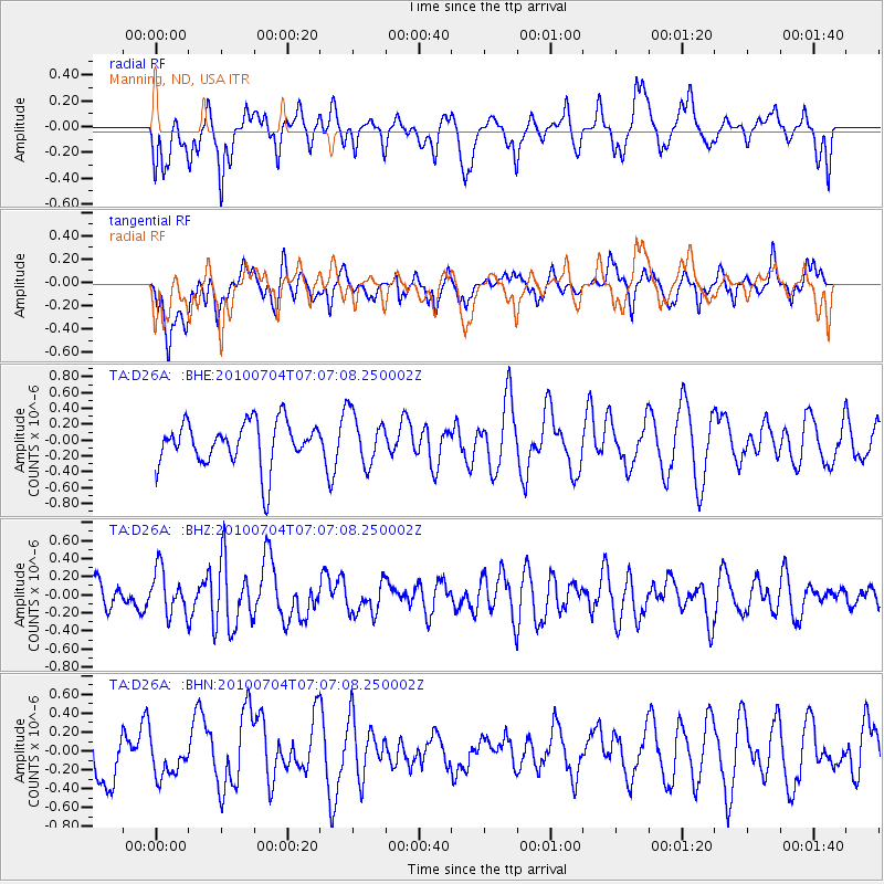
D26A Manning, ND, USA - Earthquake Result Viewer
*The percent match for this event was below the threshold and hence no stack was calculated.
| Earthquake location: |
Off Coast Of Northern Peru |
| Earthquake latitude/longitude: |
-8.5/-80.5 |
| Earthquake time(UTC): |
2010/07/04 (185) 06:57:44 GMT |
| Earthquake Depth: |
29 km |
| Earthquake Magnitude: |
5.7 MW, 5.3 MB, 5.6 MW |
| Earthquake Catalog/Contributor: |
WHDF/NEIC |
|
| Network: |
TA USArray Transportable Network (new EarthScope stations) |
| Station: |
D26A Manning, ND, USA |
| Lat/Lon: |
47.03 N/102.44 W |
| Elevation: |
693 m |
|
| Distance: |
58.6 deg |
| Az: |
342.559 deg |
| Baz: |
154.313 deg |
| Ray Param: |
$rayparam |
*The percent match for this event was below the threshold and hence was not used in the summary stack. |
|
| Radial Match: |
65.09108 % |
| Radial Bump: |
400 |
| Transverse Match: |
44.228394 % |
| Transverse Bump: |
400 |
| SOD ConfigId: |
319893 |
| Insert Time: |
2011-01-04 23:47:28.873 +0000 |
| GWidth: |
2.5 |
| Max Bumps: |
400 |
| Tol: |
0.001 |
|
Signal To Noise
| Channel | StoN | STA | LTA |
| TA:D26A: :BHZ:20100704T07:07:08.250002Z | 1.6300055 | 2.4459484E-7 | 1.5005767E-7 |
| TA:D26A: :BHN:20100704T07:07:08.250002Z | 0.5533206 | 1.8365546E-7 | 3.319151E-7 |
| TA:D26A: :BHE:20100704T07:07:08.250002Z | 1.1438444 | 3.1828012E-7 | 2.7825473E-7 |
| Arrivals |
| Ps | |
| PpPs | |
| PsPs/PpSs | |


