You are here: Home > Network List > TA - USArray Transportable Network (new EarthScope stations) Stations List
> Station 533A Kerrville, TX, USA > Earthquake Result Viewer
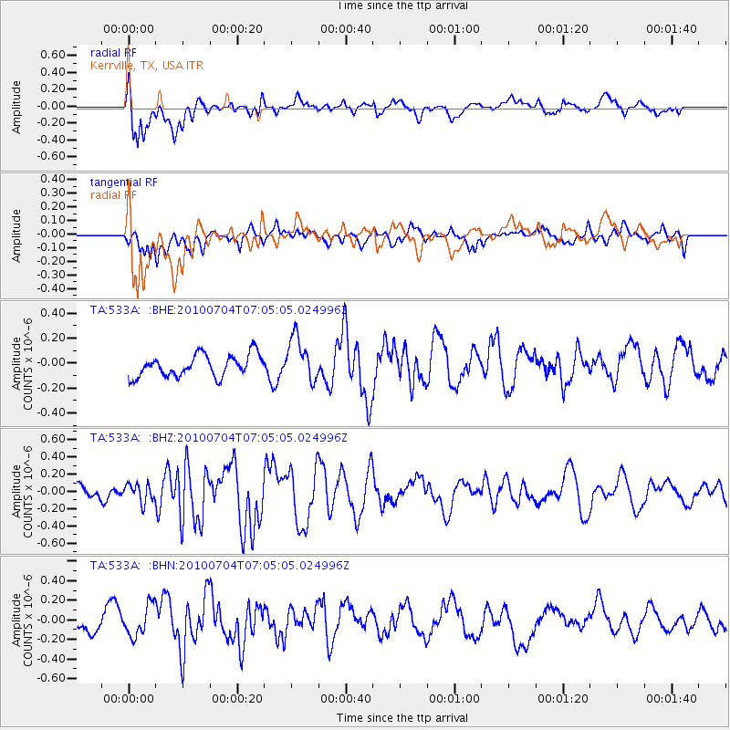
533A Kerrville, TX, USA - Earthquake Result Viewer
*The percent match for this event was below the threshold and hence no stack was calculated.
| Earthquake location: |
Off Coast Of Northern Peru |
| Earthquake latitude/longitude: |
-8.5/-80.5 |
| Earthquake time(UTC): |
2010/07/04 (185) 06:57:44 GMT |
| Earthquake Depth: |
29 km |
| Earthquake Magnitude: |
5.7 MW, 5.3 MB, 5.6 MW |
| Earthquake Catalog/Contributor: |
WHDF/NEIC |
|
| Network: |
TA USArray Transportable Network (new EarthScope stations) |
| Station: |
533A Kerrville, TX, USA |
| Lat/Lon: |
30.07 N/99.04 W |
| Elevation: |
556 m |
|
| Distance: |
42.3 deg |
| Az: |
335.778 deg |
| Baz: |
152.082 deg |
| Ray Param: |
$rayparam |
*The percent match for this event was below the threshold and hence was not used in the summary stack. |
|
| Radial Match: |
63.92683 % |
| Radial Bump: |
400 |
| Transverse Match: |
51.284798 % |
| Transverse Bump: |
400 |
| SOD ConfigId: |
319893 |
| Insert Time: |
2011-01-04 23:48:19.625 +0000 |
| GWidth: |
2.5 |
| Max Bumps: |
400 |
| Tol: |
0.001 |
|
Signal To Noise
| Channel | StoN | STA | LTA |
| TA:533A: :BHZ:20100704T07:05:05.024996Z | 1.1813638 | 1.0698699E-7 | 9.056226E-8 |
| TA:533A: :BHN:20100704T07:05:05.024996Z | 1.440821 | 1.6982005E-7 | 1.17863394E-7 |
| TA:533A: :BHE:20100704T07:05:05.024996Z | 2.0461452 | 1.7728962E-7 | 8.664567E-8 |
| Arrivals |
| Ps | |
| PpPs | |
| PsPs/PpSs | |


