You are here: Home > Network List > IW - Intermountain West Stations List
> Station PLID Pearl Lake, Idaho, USA > Earthquake Result Viewer
PLID Pearl Lake, Idaho, USA - Earthquake Result Viewer
| Earthquake location: |
Southeast Of Loyalty Islands |
| Earthquake latitude/longitude: |
-22.0/169.4 |
| Earthquake time(UTC): |
2018/12/05 (339) 04:18:08 GMT |
| Earthquake Depth: |
10 km |
| Earthquake Magnitude: |
7.5 Mww |
| Earthquake Catalog/Contributor: |
NEIC PDE/us |
|
| Network: |
IW Intermountain West |
| Station: |
PLID Pearl Lake, Idaho, USA |
| Lat/Lon: |
45.09 N/116.00 W |
| Elevation: |
2164 m |
|
| Distance: |
95.0 deg |
| Az: |
43.27 deg |
| Baz: |
243.918 deg |
| Ray Param: |
0.040895235 |
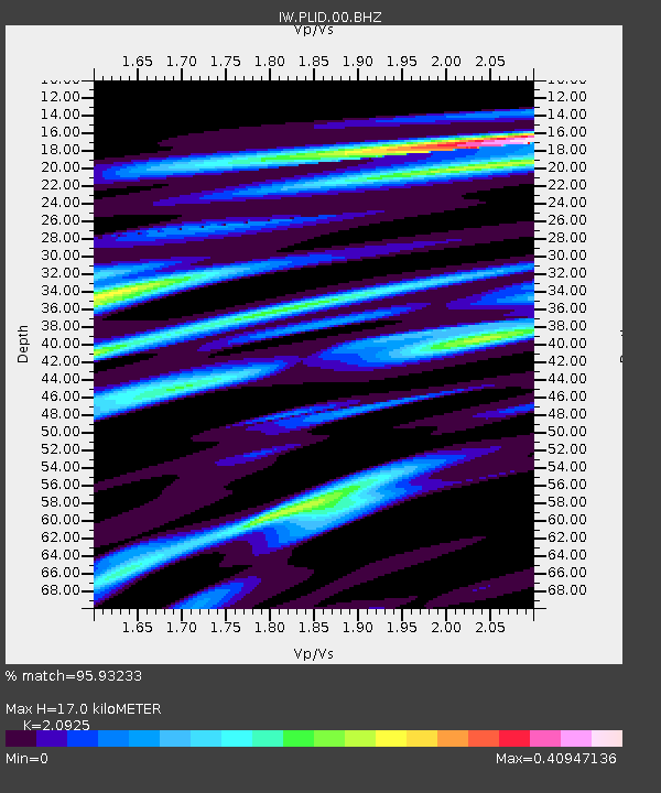
| Estimated Moho Depth: |
17.0 km |
| Estimated Crust Vp/Vs: |
2.09 |
| Assumed Crust Vp: |
6.571 km/s |
| Estimated Crust Vs: |
3.14 km/s |
| Estimated Crust Poisson's Ratio: |
0.35 |
|
| Radial Match: |
95.93233 % |
| Radial Bump: |
347 |
| Transverse Match: |
85.43341 % |
| Transverse Bump: |
400 |
| SOD ConfigId: |
3201911 |
| Insert Time: |
2018-12-19 04:25:23.966 +0000 |
| GWidth: |
2.5 |
| Max Bumps: |
400 |
| Tol: |
0.001 |
|
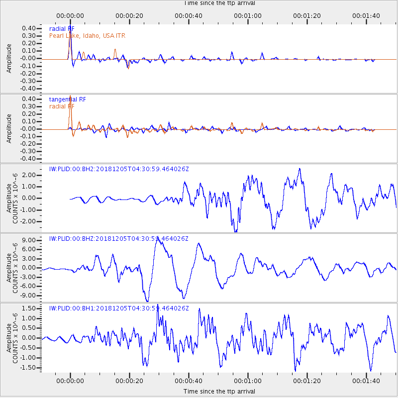
Signal To Noise
| Channel | StoN | STA | LTA |
| IW:PLID:00:BHZ:20181205T04:30:59.464026Z | 3.47489 | 6.4674674E-7 | 1.8612006E-7 |
| IW:PLID:00:BH1:20181205T04:30:59.464026Z | 1.1747302 | 1.3744398E-7 | 1.17000454E-7 |
| IW:PLID:00:BH2:20181205T04:30:59.464026Z | 1.5121696 | 2.2649589E-7 | 1.4978207E-7 |
| Arrivals |
| Ps | 2.9 SECOND |
| PpPs | 7.9 SECOND |
| PsPs/PpSs | 11 SECOND |


