You are here: Home > Network List > UU - University of Utah Regional Network Stations List
> Station RDMU Red Mountain, UT, USA > Earthquake Result Viewer
RDMU Red Mountain, UT, USA - Earthquake Result Viewer
| Earthquake location: |
Southeast Of Loyalty Islands |
| Earthquake latitude/longitude: |
-22.0/169.4 |
| Earthquake time(UTC): |
2018/12/05 (339) 04:18:08 GMT |
| Earthquake Depth: |
10 km |
| Earthquake Magnitude: |
7.5 Mww |
| Earthquake Catalog/Contributor: |
NEIC PDE/us |
|
| Network: |
UU University of Utah Regional Network |
| Station: |
RDMU Red Mountain, UT, USA |
| Lat/Lon: |
40.57 N/109.57 W |
| Elevation: |
2087 m |
|
| Distance: |
97.5 deg |
| Az: |
49.358 deg |
| Baz: |
247.616 deg |
| Ray Param: |
0.040201973 |
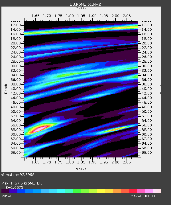
| Estimated Moho Depth: |
57.5 km |
| Estimated Crust Vp/Vs: |
1.67 |
| Assumed Crust Vp: |
6.207 km/s |
| Estimated Crust Vs: |
3.722 km/s |
| Estimated Crust Poisson's Ratio: |
0.22 |
|
| Radial Match: |
92.6998 % |
| Radial Bump: |
355 |
| Transverse Match: |
74.88519 % |
| Transverse Bump: |
400 |
| SOD ConfigId: |
3201911 |
| Insert Time: |
2018-12-19 04:26:54.189 +0000 |
| GWidth: |
2.5 |
| Max Bumps: |
400 |
| Tol: |
0.001 |
|
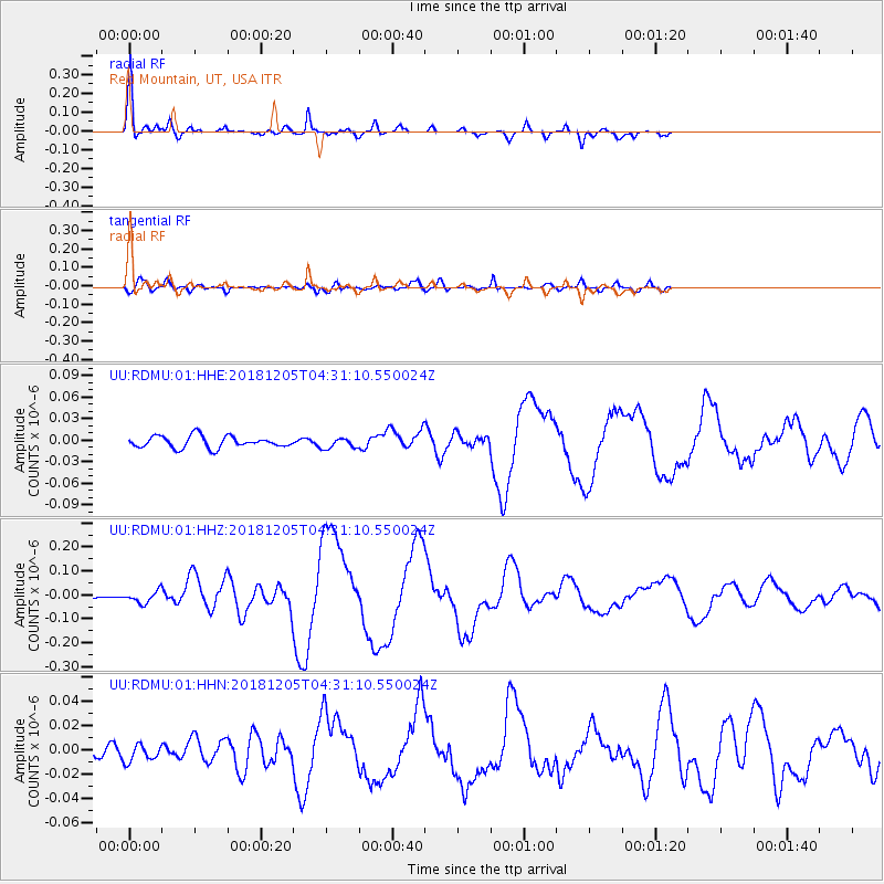
Signal To Noise
| Channel | StoN | STA | LTA |
| UU:RDMU:01:HHZ:20181205T04:31:10.550024Z | 3.81627 | 2.4031008E-8 | 6.2969887E-9 |
| UU:RDMU:01:HHN:20181205T04:31:10.550024Z | 1.3419435 | 6.76791E-9 | 5.043364E-9 |
| UU:RDMU:01:HHE:20181205T04:31:10.550024Z | 0.8589214 | 7.0318205E-9 | 8.186802E-9 |
| Arrivals |
| Ps | 6.3 SECOND |
| PpPs | 24 SECOND |
| PsPs/PpSs | 31 SECOND |


