You are here: Home > Network List > WY - Yellowstone Wyoming Seismic Network Stations List
> Station YHH Holmes Hill, YNP, WY, USA > Earthquake Result Viewer
YHH Holmes Hill, YNP, WY, USA - Earthquake Result Viewer
| Earthquake location: |
Southeast Of Loyalty Islands |
| Earthquake latitude/longitude: |
-22.0/169.4 |
| Earthquake time(UTC): |
2018/12/05 (339) 04:18:08 GMT |
| Earthquake Depth: |
10 km |
| Earthquake Magnitude: |
7.5 Mww |
| Earthquake Catalog/Contributor: |
NEIC PDE/us |
|
| Network: |
WY Yellowstone Wyoming Seismic Network |
| Station: |
YHH Holmes Hill, YNP, WY, USA |
| Lat/Lon: |
44.79 N/110.85 W |
| Elevation: |
2717 m |
|
| Distance: |
98.2 deg |
| Az: |
45.063 deg |
| Baz: |
247.337 deg |
| Ray Param: |
0.03997036 |
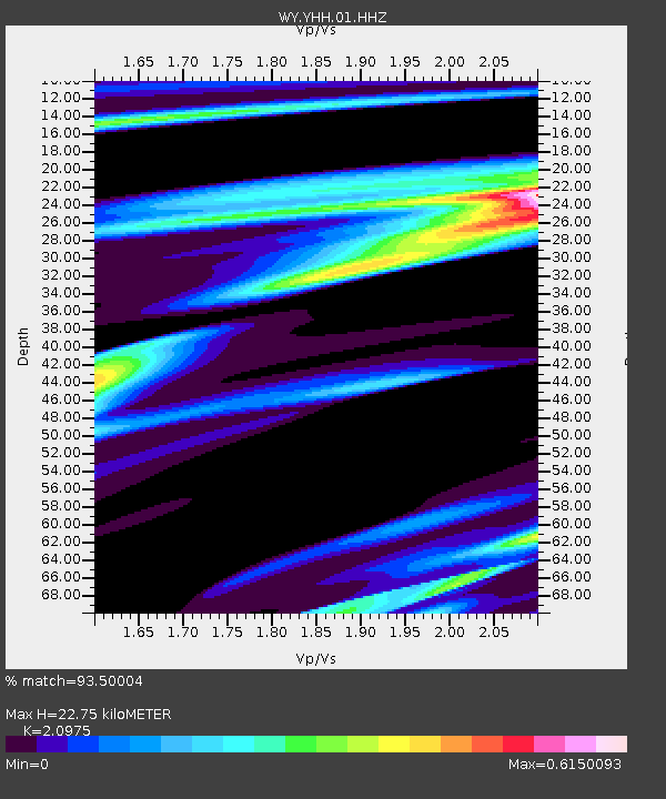
| Estimated Moho Depth: |
22.75 km |
| Estimated Crust Vp/Vs: |
2.10 |
| Assumed Crust Vp: |
6.35 km/s |
| Estimated Crust Vs: |
3.027 km/s |
| Estimated Crust Poisson's Ratio: |
0.35 |
|
| Radial Match: |
93.50004 % |
| Radial Bump: |
353 |
| Transverse Match: |
93.251045 % |
| Transverse Bump: |
338 |
| SOD ConfigId: |
3201911 |
| Insert Time: |
2018-12-19 04:27:15.500 +0000 |
| GWidth: |
2.5 |
| Max Bumps: |
400 |
| Tol: |
0.001 |
|
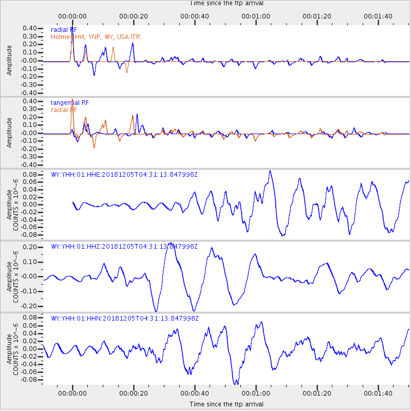
Signal To Noise
| Channel | StoN | STA | LTA |
| WY:YHH:01:HHZ:20181205T04:31:13.847998Z | 2.0458157 | 1.6274631E-8 | 7.955083E-9 |
| WY:YHH:01:HHN:20181205T04:31:13.847998Z | 0.7398085 | 8.352491E-9 | 1.1290072E-8 |
| WY:YHH:01:HHE:20181205T04:31:13.847998Z | 1.3692622 | 7.156313E-9 | 5.2264E-9 |
| Arrivals |
| Ps | 4.0 SECOND |
| PpPs | 11 SECOND |
| PsPs/PpSs | 15 SECOND |


