You are here: Home > Network List > MB - Montana Regional Seismic Network Stations List
> Station LIMT Lima, MT > Earthquake Result Viewer
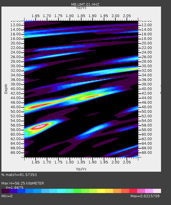
LIMT Lima, MT - Earthquake Result Viewer
| Earthquake location: |
South Of Panama |
| Earthquake latitude/longitude: |
5.6/-82.6 |
| Earthquake time(UTC): |
2023/08/03 (215) 01:25:21 GMT |
| Earthquake Depth: |
8.0 km |
| Earthquake Magnitude: |
5.9 mww |
| Earthquake Catalog/Contributor: |
NEIC PDE/us |
|
| Network: |
MB Montana Regional Seismic Network |
| Station: |
LIMT Lima, MT |
| Lat/Lon: |
44.62 N/112.64 W |
| Elevation: |
1956 m |
|
| Distance: |
46.9 deg |
| Az: |
330.684 deg |
| Baz: |
136.975 deg |
| Ray Param: |
0.070381105 |
| Estimated Moho Depth: |
56.25 km |
| Estimated Crust Vp/Vs: |
1.67 |
| Assumed Crust Vp: |
6.577 km/s |
| Estimated Crust Vs: |
3.944 km/s |
| Estimated Crust Poisson's Ratio: |
0.22 |
|
| Radial Match: |
91.57353 % |
| Radial Bump: |
400 |
| Transverse Match: |
82.19516 % |
| Transverse Bump: |
400 |
| SOD ConfigId: |
31937991 |
| Insert Time: |
2023-08-17 01:46:30.515 +0000 |
| GWidth: |
2.5 |
| Max Bumps: |
400 |
| Tol: |
0.001 |
|

Signal To Noise
| Channel | StoN | STA | LTA |
| MB:LIMT:01:HHZ:20230803T01:33:21.180013Z | 22.008102 | 1.8596338E-6 | 8.449769E-8 |
| MB:LIMT:01:HHN:20230803T01:33:21.180013Z | 7.8168855 | 4.8165094E-7 | 6.161673E-8 |
| MB:LIMT:01:HHE:20230803T01:33:21.180013Z | 6.0758724 | 4.7140986E-7 | 7.758719E-8 |
| Arrivals |
| Ps | 6.1 SECOND |
| PpPs | 21 SECOND |
| PsPs/PpSs | 27 SECOND |


