You are here: Home > Network List > N4 - Central and EAstern US Network Stations List
> Station M52A Chesterland, OH, USA > Earthquake Result Viewer
M52A Chesterland, OH, USA - Earthquake Result Viewer
| Earthquake location: |
South Of Panama |
| Earthquake latitude/longitude: |
5.6/-82.6 |
| Earthquake time(UTC): |
2023/08/03 (215) 01:25:21 GMT |
| Earthquake Depth: |
8.0 km |
| Earthquake Magnitude: |
5.9 mww |
| Earthquake Catalog/Contributor: |
NEIC PDE/us |
|
| Network: |
N4 Central and EAstern US Network |
| Station: |
M52A Chesterland, OH, USA |
| Lat/Lon: |
41.54 N/81.36 W |
| Elevation: |
382 m |
|
| Distance: |
35.8 deg |
| Az: |
1.624 deg |
| Baz: |
182.154 deg |
| Ray Param: |
0.07704942 |
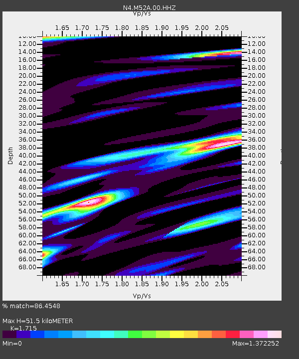
| Estimated Moho Depth: |
51.5 km |
| Estimated Crust Vp/Vs: |
1.72 |
| Assumed Crust Vp: |
6.483 km/s |
| Estimated Crust Vs: |
3.78 km/s |
| Estimated Crust Poisson's Ratio: |
0.24 |
|
| Radial Match: |
86.4548 % |
| Radial Bump: |
400 |
| Transverse Match: |
54.451283 % |
| Transverse Bump: |
400 |
| SOD ConfigId: |
31937991 |
| Insert Time: |
2023-08-17 01:47:51.141 +0000 |
| GWidth: |
2.5 |
| Max Bumps: |
400 |
| Tol: |
0.001 |
|

Signal To Noise
| Channel | StoN | STA | LTA |
| N4:M52A:00:HHZ:20230803T01:31:50.188985Z | 8.521653 | 4.1965455E-7 | 4.9245674E-8 |
| N4:M52A:00:HH1:20230803T01:31:50.188985Z | 7.4527965 | 4.4930835E-7 | 6.028722E-8 |
| N4:M52A:00:HH2:20230803T01:31:50.188985Z | 2.3237782 | 1.3003721E-7 | 5.595939E-8 |
| Arrivals |
| Ps | 6.2 SECOND |
| PpPs | 20 SECOND |
| PsPs/PpSs | 26 SECOND |


