You are here: Home > Network List > N4 - Central and EAstern US Network Stations List
> Station Q56A Snyder Ridge, Maysville, WV, USA > Earthquake Result Viewer
Q56A Snyder Ridge, Maysville, WV, USA - Earthquake Result Viewer
| Earthquake location: |
South Of Panama |
| Earthquake latitude/longitude: |
5.6/-82.6 |
| Earthquake time(UTC): |
2023/08/03 (215) 01:25:21 GMT |
| Earthquake Depth: |
8.0 km |
| Earthquake Magnitude: |
5.9 mww |
| Earthquake Catalog/Contributor: |
NEIC PDE/us |
|
| Network: |
N4 Central and EAstern US Network |
| Station: |
Q56A Snyder Ridge, Maysville, WV, USA |
| Lat/Lon: |
39.04 N/79.19 W |
| Elevation: |
430 m |
|
| Distance: |
33.4 deg |
| Az: |
4.862 deg |
| Baz: |
186.218 deg |
| Ray Param: |
0.078243926 |
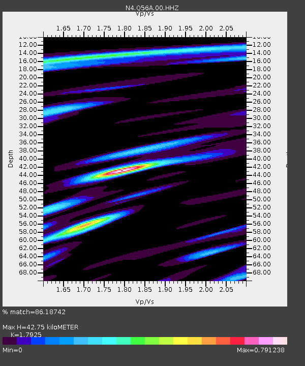
| Estimated Moho Depth: |
42.75 km |
| Estimated Crust Vp/Vs: |
1.79 |
| Assumed Crust Vp: |
6.159 km/s |
| Estimated Crust Vs: |
3.436 km/s |
| Estimated Crust Poisson's Ratio: |
0.27 |
|
| Radial Match: |
86.18742 % |
| Radial Bump: |
374 |
| Transverse Match: |
75.64113 % |
| Transverse Bump: |
400 |
| SOD ConfigId: |
31937991 |
| Insert Time: |
2023-08-17 01:48:36.235 +0000 |
| GWidth: |
2.5 |
| Max Bumps: |
400 |
| Tol: |
0.001 |
|

Signal To Noise
| Channel | StoN | STA | LTA |
| N4:Q56A:00:HHZ:20230803T01:31:29.740011Z | 7.3782997 | 7.2964235E-7 | 9.889031E-8 |
| N4:Q56A:00:HH1:20230803T01:31:29.740011Z | 9.721224 | 4.6097395E-7 | 4.7419334E-8 |
| N4:Q56A:00:HH2:20230803T01:31:29.740011Z | 2.3384426 | 1.2702591E-7 | 5.432073E-8 |
| Arrivals |
| Ps | 5.9 SECOND |
| PpPs | 18 SECOND |
| PsPs/PpSs | 24 SECOND |


