You are here: Home > Network List > NM - Cooperative New Madrid Seismic Network Stations List
> Station MGMO Mountain Grove, MO > Earthquake Result Viewer
MGMO Mountain Grove, MO - Earthquake Result Viewer
| Earthquake location: |
South Of Panama |
| Earthquake latitude/longitude: |
5.6/-82.6 |
| Earthquake time(UTC): |
2023/08/03 (215) 01:25:21 GMT |
| Earthquake Depth: |
8.0 km |
| Earthquake Magnitude: |
5.9 mww |
| Earthquake Catalog/Contributor: |
NEIC PDE/us |
|
| Network: |
NM Cooperative New Madrid Seismic Network |
| Station: |
MGMO Mountain Grove, MO |
| Lat/Lon: |
37.15 N/92.27 W |
| Elevation: |
453 m |
|
| Distance: |
32.6 deg |
| Az: |
345.606 deg |
| Baz: |
161.962 deg |
| Ray Param: |
0.07860275 |
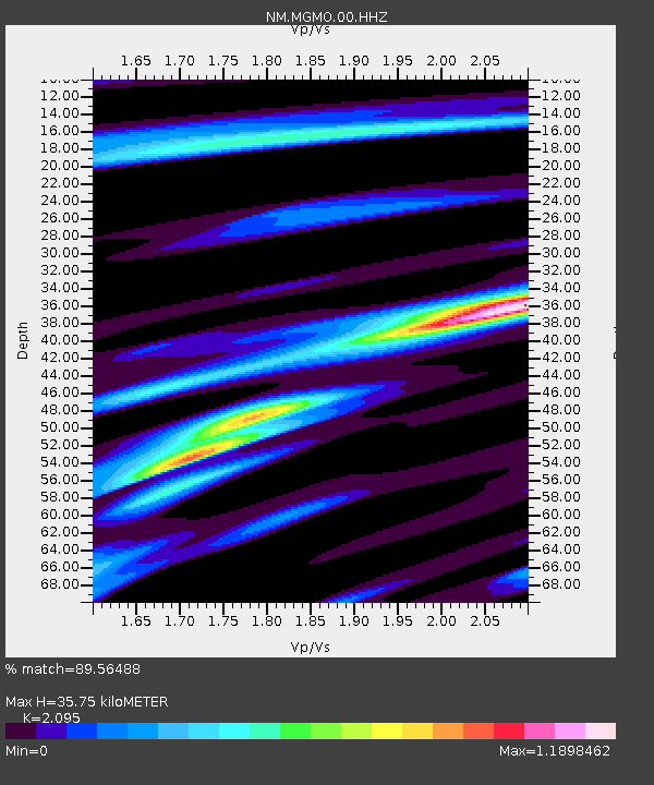
| Estimated Moho Depth: |
35.75 km |
| Estimated Crust Vp/Vs: |
2.10 |
| Assumed Crust Vp: |
6.53 km/s |
| Estimated Crust Vs: |
3.117 km/s |
| Estimated Crust Poisson's Ratio: |
0.35 |
|
| Radial Match: |
89.56488 % |
| Radial Bump: |
273 |
| Transverse Match: |
68.27253 % |
| Transverse Bump: |
400 |
| SOD ConfigId: |
31937991 |
| Insert Time: |
2023-08-17 01:49:59.132 +0000 |
| GWidth: |
2.5 |
| Max Bumps: |
400 |
| Tol: |
0.001 |
|

Signal To Noise
| Channel | StoN | STA | LTA |
| NM:MGMO:00:HHZ:20230803T01:31:22.670003Z | 23.302734 | 1.2395652E-6 | 5.3193983E-8 |
| NM:MGMO:00:HHN:20230803T01:31:22.670003Z | 16.105917 | 7.345021E-7 | 4.5604487E-8 |
| NM:MGMO:00:HHE:20230803T01:31:22.670003Z | 5.981576 | 2.3260112E-7 | 3.8886263E-8 |
| Arrivals |
| Ps | 6.4 SECOND |
| PpPs | 16 SECOND |
| PsPs/PpSs | 22 SECOND |


