You are here: Home > Network List > O2 - Oklahoma Consolidated Temporary Seismic Networks Stations List
> Station SC12 Granite, Oklahoma, USA > Earthquake Result Viewer
SC12 Granite, Oklahoma, USA - Earthquake Result Viewer
| Earthquake location: |
South Of Panama |
| Earthquake latitude/longitude: |
5.6/-82.6 |
| Earthquake time(UTC): |
2023/08/03 (215) 01:25:21 GMT |
| Earthquake Depth: |
8.0 km |
| Earthquake Magnitude: |
5.9 mww |
| Earthquake Catalog/Contributor: |
NEIC PDE/us |
|
| Network: |
O2 Oklahoma Consolidated Temporary Seismic Networks |
| Station: |
SC12 Granite, Oklahoma, USA |
| Lat/Lon: |
34.92 N/99.35 W |
| Elevation: |
472 m |
|
| Distance: |
33.0 deg |
| Az: |
334.246 deg |
| Baz: |
148.247 deg |
| Ray Param: |
0.07841928 |
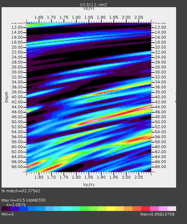
| Estimated Moho Depth: |
43.5 km |
| Estimated Crust Vp/Vs: |
2.10 |
| Assumed Crust Vp: |
6.315 km/s |
| Estimated Crust Vs: |
3.011 km/s |
| Estimated Crust Poisson's Ratio: |
0.35 |
|
| Radial Match: |
82.37562 % |
| Radial Bump: |
400 |
| Transverse Match: |
72.27969 % |
| Transverse Bump: |
400 |
| SOD ConfigId: |
31937991 |
| Insert Time: |
2023-08-17 01:52:35.198 +0000 |
| GWidth: |
2.5 |
| Max Bumps: |
400 |
| Tol: |
0.001 |
|

Signal To Noise
| Channel | StoN | STA | LTA |
| O2:SC12: :HHZ:20230803T01:31:26.164999Z | 11.738352 | 5.9053883E-7 | 5.0308497E-8 |
| O2:SC12: :HHN:20230803T01:31:26.164999Z | 4.5094233 | 3.163206E-7 | 7.014658E-8 |
| O2:SC12: :HHE:20230803T01:31:26.164999Z | 8.196406 | 3.430324E-7 | 4.1851564E-8 |
| Arrivals |
| Ps | 8.1 SECOND |
| PpPs | 20 SECOND |
| PsPs/PpSs | 28 SECOND |


