You are here: Home > Network List > O2 - Oklahoma Consolidated Temporary Seismic Networks Stations List
> Station TUTT Tuttle, Oklahoma, USA > Earthquake Result Viewer
TUTT Tuttle, Oklahoma, USA - Earthquake Result Viewer
| Earthquake location: |
South Of Panama |
| Earthquake latitude/longitude: |
5.6/-82.6 |
| Earthquake time(UTC): |
2023/08/03 (215) 01:25:21 GMT |
| Earthquake Depth: |
8.0 km |
| Earthquake Magnitude: |
5.9 mww |
| Earthquake Catalog/Contributor: |
NEIC PDE/us |
|
| Network: |
O2 Oklahoma Consolidated Temporary Seismic Networks |
| Station: |
TUTT Tuttle, Oklahoma, USA |
| Lat/Lon: |
35.24 N/97.76 W |
| Elevation: |
407 m |
|
| Distance: |
32.6 deg |
| Az: |
336.631 deg |
| Baz: |
151.167 deg |
| Ray Param: |
0.078597106 |
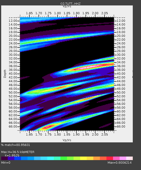
| Estimated Moho Depth: |
36.5 km |
| Estimated Crust Vp/Vs: |
1.95 |
| Assumed Crust Vp: |
6.426 km/s |
| Estimated Crust Vs: |
3.291 km/s |
| Estimated Crust Poisson's Ratio: |
0.32 |
|
| Radial Match: |
80.95631 % |
| Radial Bump: |
309 |
| Transverse Match: |
60.725502 % |
| Transverse Bump: |
383 |
| SOD ConfigId: |
31937991 |
| Insert Time: |
2023-08-17 01:52:54.857 +0000 |
| GWidth: |
2.5 |
| Max Bumps: |
400 |
| Tol: |
0.001 |
|

Signal To Noise
| Channel | StoN | STA | LTA |
| O2:TUTT: :HHZ:20230803T01:31:22.775014Z | 11.156129 | 1.0310675E-6 | 9.242162E-8 |
| O2:TUTT: :HHN:20230803T01:31:22.775014Z | 4.507043 | 4.3418052E-7 | 9.633379E-8 |
| O2:TUTT: :HHE:20230803T01:31:22.775014Z | 2.0789037 | 2.0346361E-7 | 9.787063E-8 |
| Arrivals |
| Ps | 5.8 SECOND |
| PpPs | 16 SECOND |
| PsPs/PpSs | 21 SECOND |


