You are here: Home > Network List > US - United States National Seismic Network Stations List
> Station HAWA Hanford, Washington, USA > Earthquake Result Viewer
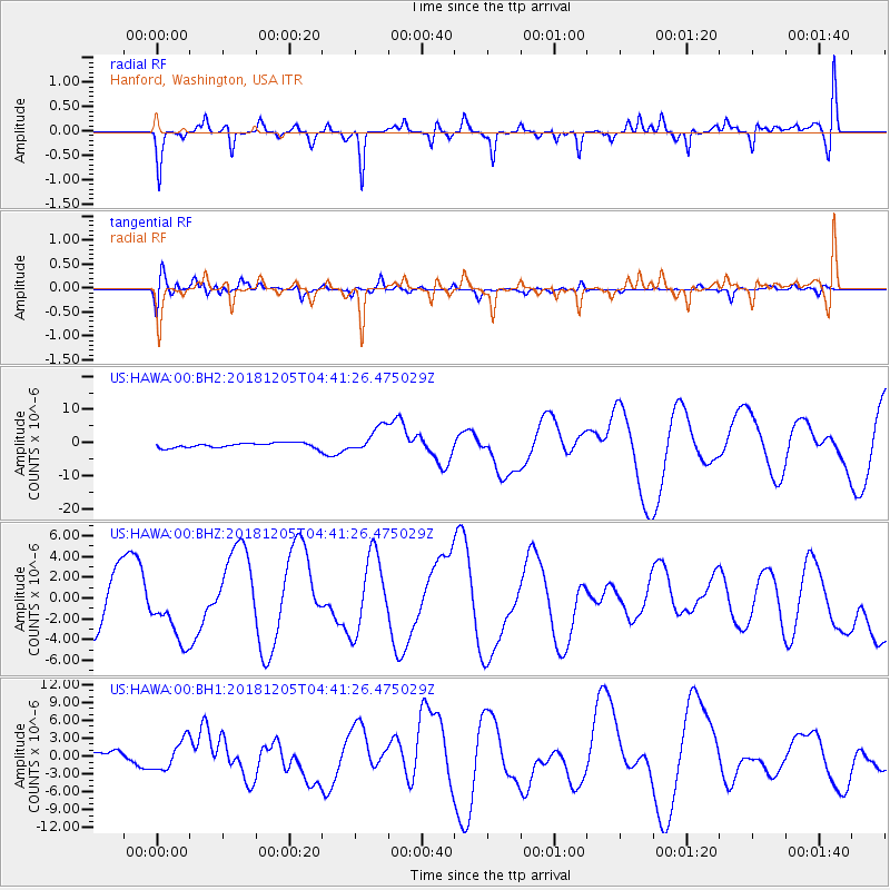
HAWA Hanford, Washington, USA - Earthquake Result Viewer
*The percent match for this event was below the threshold and hence no stack was calculated.
| Earthquake location: |
Southeast Of Loyalty Islands |
| Earthquake latitude/longitude: |
-21.5/169.4 |
| Earthquake time(UTC): |
2018/12/05 (339) 04:28:44 GMT |
| Earthquake Depth: |
10 km |
| Earthquake Magnitude: |
5.9 mb |
| Earthquake Catalog/Contributor: |
NEIC PDE/us |
|
| Network: |
US United States National Seismic Network |
| Station: |
HAWA Hanford, Washington, USA |
| Lat/Lon: |
46.39 N/119.53 W |
| Elevation: |
364 m |
|
| Distance: |
93.1 deg |
| Az: |
40.98 deg |
| Baz: |
241.917 deg |
| Ray Param: |
$rayparam |
*The percent match for this event was below the threshold and hence was not used in the summary stack. |
|
| Radial Match: |
65.27387 % |
| Radial Bump: |
382 |
| Transverse Match: |
59.345238 % |
| Transverse Bump: |
400 |
| SOD ConfigId: |
3201911 |
| Insert Time: |
2018-12-19 04:31:26.196 +0000 |
| GWidth: |
2.5 |
| Max Bumps: |
400 |
| Tol: |
0.001 |
|
Signal To Noise
| Channel | StoN | STA | LTA |
| US:HAWA:00:BHZ:20181205T04:41:26.475029Z | 1.3741835 | 3.004492E-6 | 2.1863834E-6 |
| US:HAWA:00:BH1:20181205T04:41:26.475029Z | 2.0787594 | 2.457377E-6 | 1.1821363E-6 |
| US:HAWA:00:BH2:20181205T04:41:26.475029Z | 5.4868608 | 3.9221E-6 | 7.1481674E-7 |
| Arrivals |
| Ps | |
| PpPs | |
| PsPs/PpSs | |


