You are here: Home > Network List > IU - Global Seismograph Network (GSN - IRIS/USGS) Stations List
> Station CTAO Charters Towers, Australia > Earthquake Result Viewer
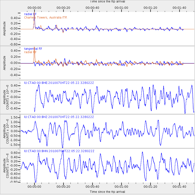
CTAO Charters Towers, Australia - Earthquake Result Viewer
*The percent match for this event was below the threshold and hence no stack was calculated.
| Earthquake location: |
Near East Coast Of Honshu, Japan |
| Earthquake latitude/longitude: |
39.7/142.4 |
| Earthquake time(UTC): |
2010/07/04 (185) 21:55:51 GMT |
| Earthquake Depth: |
27 km |
| Earthquake Magnitude: |
6.4 MB, 6.1 MS, 6.3 MW, 6.2 MW |
| Earthquake Catalog/Contributor: |
WHDF/NEIC |
|
| Network: |
IU Global Seismograph Network (GSN - IRIS/USGS) |
| Station: |
CTAO Charters Towers, Australia |
| Lat/Lon: |
20.09 S/146.25 E |
| Elevation: |
357 m |
|
| Distance: |
59.6 deg |
| Az: |
175.765 deg |
| Baz: |
356.524 deg |
| Ray Param: |
$rayparam |
*The percent match for this event was below the threshold and hence was not used in the summary stack. |
|
| Radial Match: |
79.419365 % |
| Radial Bump: |
333 |
| Transverse Match: |
54.574703 % |
| Transverse Bump: |
400 |
| SOD ConfigId: |
319893 |
| Insert Time: |
2011-01-05 00:03:41.164 +0000 |
| GWidth: |
2.5 |
| Max Bumps: |
400 |
| Tol: |
0.001 |
|
Signal To Noise
| Channel | StoN | STA | LTA |
| IU:CTAO:00:BHZ:20100704T22:05:22.328022Z | 3.4257162 | 7.342214E-7 | 2.1432639E-7 |
| IU:CTAO:00:BHN:20100704T22:05:22.328022Z | 2.5725183 | 4.3039273E-7 | 1.6730405E-7 |
| IU:CTAO:00:BHE:20100704T22:05:22.328022Z | 0.96628684 | 1.7730088E-7 | 1.834868E-7 |
| Arrivals |
| Ps | |
| PpPs | |
| PsPs/PpSs | |


