You are here: Home > Network List > IW - Intermountain West Stations List
> Station REDW Red Top Meadow, Wyoming, USA > Earthquake Result Viewer
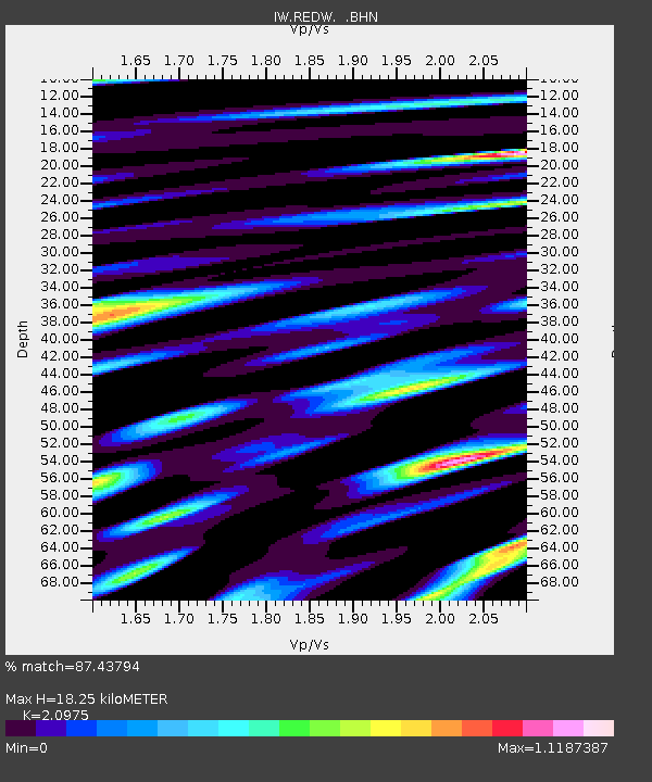
REDW Red Top Meadow, Wyoming, USA - Earthquake Result Viewer
| Earthquake location: |
Near East Coast Of Honshu, Japan |
| Earthquake latitude/longitude: |
39.7/142.4 |
| Earthquake time(UTC): |
2010/07/04 (185) 21:55:51 GMT |
| Earthquake Depth: |
27 km |
| Earthquake Magnitude: |
6.4 MB, 6.1 MS, 6.3 MW, 6.2 MW |
| Earthquake Catalog/Contributor: |
WHDF/NEIC |
|
| Network: |
IW Intermountain West |
| Station: |
REDW Red Top Meadow, Wyoming, USA |
| Lat/Lon: |
43.36 N/110.85 W |
| Elevation: |
2192 m |
|
| Distance: |
74.2 deg |
| Az: |
46.536 deg |
| Baz: |
309.842 deg |
| Ray Param: |
0.052480087 |
| Estimated Moho Depth: |
18.25 km |
| Estimated Crust Vp/Vs: |
2.10 |
| Assumed Crust Vp: |
6.207 km/s |
| Estimated Crust Vs: |
2.959 km/s |
| Estimated Crust Poisson's Ratio: |
0.35 |
|
| Radial Match: |
87.43794 % |
| Radial Bump: |
400 |
| Transverse Match: |
85.52395 % |
| Transverse Bump: |
400 |
| SOD ConfigId: |
319893 |
| Insert Time: |
2011-01-05 00:03:58.961 +0000 |
| GWidth: |
2.5 |
| Max Bumps: |
400 |
| Tol: |
0.001 |
|

Signal To Noise
| Channel | StoN | STA | LTA |
| IW:REDW: :BHZ:20100704T22:06:54.914998Z | 15.576195 | 1.0251749E-6 | 6.581677E-8 |
| IW:REDW: :BHN:20100704T22:06:54.914998Z | 1.9834023 | 2.1546828E-7 | 1.0863569E-7 |
| IW:REDW: :BHE:20100704T22:06:54.914998Z | 3.1126244 | 2.9638935E-7 | 9.522169E-8 |
| Arrivals |
| Ps | 3.3 SECOND |
| PpPs | 8.9 SECOND |
| PsPs/PpSs | 12 SECOND |


