You are here: Home > Network List > UW - Pacific Northwest Regional Seismic Network Stations List
> Station RNWY Roche Harbor Airport, San Juan Island, WA, USA > Earthquake Result Viewer
RNWY Roche Harbor Airport, San Juan Island, WA, USA - Earthquake Result Viewer
| Earthquake location: |
South Of Panama |
| Earthquake latitude/longitude: |
5.6/-82.6 |
| Earthquake time(UTC): |
2023/08/03 (215) 01:25:21 GMT |
| Earthquake Depth: |
8.0 km |
| Earthquake Magnitude: |
5.9 mww |
| Earthquake Catalog/Contributor: |
NEIC PDE/us |
|
| Network: |
UW Pacific Northwest Regional Seismic Network |
| Station: |
RNWY Roche Harbor Airport, San Juan Island, WA, USA |
| Lat/Lon: |
48.61 N/123.13 W |
| Elevation: |
58 m |
|
| Distance: |
54.9 deg |
| Az: |
328.202 deg |
| Baz: |
127.796 deg |
| Ray Param: |
0.065168045 |
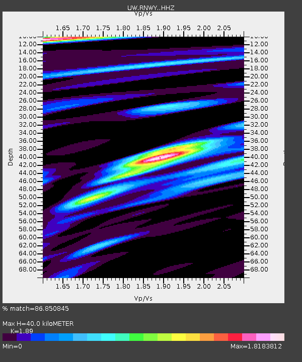
| Estimated Moho Depth: |
40.0 km |
| Estimated Crust Vp/Vs: |
1.89 |
| Assumed Crust Vp: |
6.566 km/s |
| Estimated Crust Vs: |
3.474 km/s |
| Estimated Crust Poisson's Ratio: |
0.31 |
|
| Radial Match: |
86.850845 % |
| Radial Bump: |
369 |
| Transverse Match: |
73.35653 % |
| Transverse Bump: |
400 |
| SOD ConfigId: |
31937991 |
| Insert Time: |
2023-08-17 02:04:45.989 +0000 |
| GWidth: |
2.5 |
| Max Bumps: |
400 |
| Tol: |
0.001 |
|

Signal To Noise
| Channel | StoN | STA | LTA |
| UW:RNWY: :HHZ:20230803T01:34:21.469991Z | 7.4620867 | 7.140457E-7 | 9.568982E-8 |
| UW:RNWY: :HHN:20230803T01:34:21.469991Z | 3.3182642 | 2.1466663E-7 | 6.469244E-8 |
| UW:RNWY: :HHE:20230803T01:34:21.469991Z | 4.6380844 | 3.1076155E-7 | 6.700213E-8 |
| Arrivals |
| Ps | 5.7 SECOND |
| PpPs | 17 SECOND |
| PsPs/PpSs | 22 SECOND |


