You are here: Home > Network List > IW - Intermountain West Stations List
> Station PLID Pearl Lake, Idaho, USA > Earthquake Result Viewer
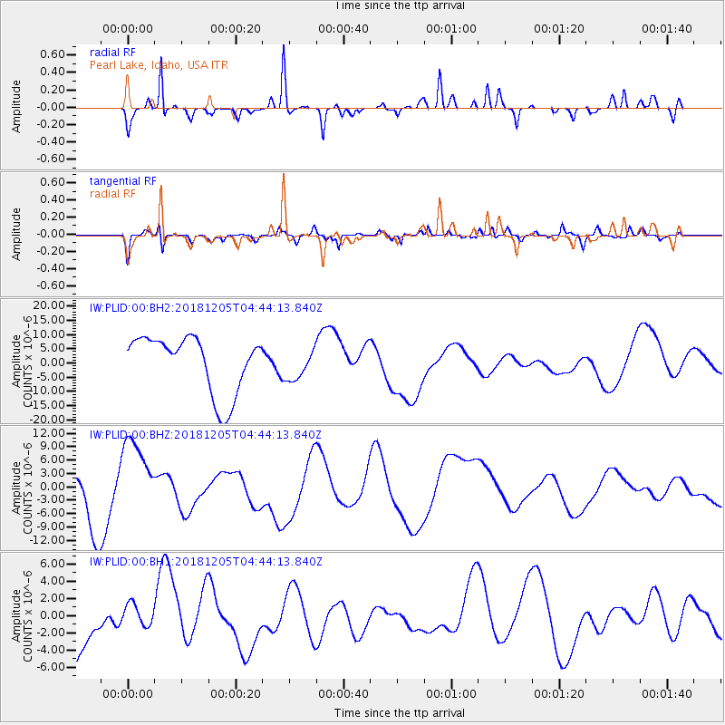
PLID Pearl Lake, Idaho, USA - Earthquake Result Viewer
*The percent match for this event was below the threshold and hence no stack was calculated.
| Earthquake location: |
Southeast Of Loyalty Islands |
| Earthquake latitude/longitude: |
-21.9/169.5 |
| Earthquake time(UTC): |
2018/12/05 (339) 04:31:23 GMT |
| Earthquake Depth: |
10 km |
| Earthquake Magnitude: |
5.6 mb |
| Earthquake Catalog/Contributor: |
NEIC PDE/us |
|
| Network: |
IW Intermountain West |
| Station: |
PLID Pearl Lake, Idaho, USA |
| Lat/Lon: |
45.09 N/116.00 W |
| Elevation: |
2164 m |
|
| Distance: |
94.9 deg |
| Az: |
43.235 deg |
| Baz: |
243.914 deg |
| Ray Param: |
$rayparam |
*The percent match for this event was below the threshold and hence was not used in the summary stack. |
|
| Radial Match: |
45.848644 % |
| Radial Bump: |
213 |
| Transverse Match: |
64.45148 % |
| Transverse Bump: |
400 |
| SOD ConfigId: |
3201911 |
| Insert Time: |
2018-12-19 04:36:00.213 +0000 |
| GWidth: |
2.5 |
| Max Bumps: |
400 |
| Tol: |
0.001 |
|
Signal To Noise
| Channel | StoN | STA | LTA |
| IW:PLID:00:BHZ:20181205T04:44:13.840Z | 1.7291003 | 8.873222E-6 | 5.131699E-6 |
| IW:PLID:00:BH1:20181205T04:44:13.840Z | 0.37620732 | 1.2618046E-6 | 3.3540139E-6 |
| IW:PLID:00:BH2:20181205T04:44:13.840Z | 0.54581374 | 5.446748E-6 | 9.979133E-6 |
| Arrivals |
| Ps | |
| PpPs | |
| PsPs/PpSs | |


