You are here: Home > Network List > IU - Global Seismograph Network (GSN - IRIS/USGS) Stations List
> Station SFJD Sondre Stromfjord, Greenland > Earthquake Result Viewer
SFJD Sondre Stromfjord, Greenland - Earthquake Result Viewer
| Earthquake location: |
Alaska Peninsula |
| Earthquake latitude/longitude: |
54.7/-161.0 |
| Earthquake time(UTC): |
2023/08/03 (215) 19:33:51 GMT |
| Earthquake Depth: |
41 km |
| Earthquake Magnitude: |
5.6 mww |
| Earthquake Catalog/Contributor: |
NEIC PDE/us |
|
| Network: |
IU Global Seismograph Network (GSN - IRIS/USGS) |
| Station: |
SFJD Sondre Stromfjord, Greenland |
| Lat/Lon: |
67.00 N/50.62 W |
| Elevation: |
330 m |
|
| Distance: |
48.0 deg |
| Az: |
29.698 deg |
| Baz: |
312.916 deg |
| Ray Param: |
0.069536775 |
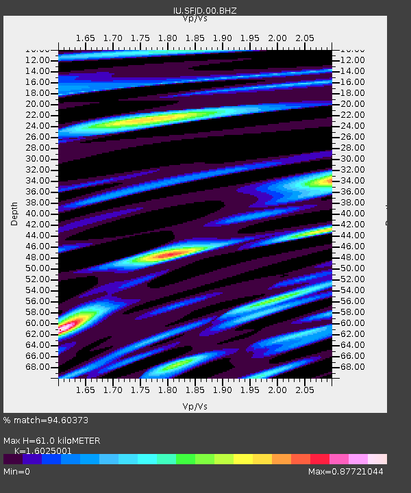
| Estimated Moho Depth: |
61.0 km |
| Estimated Crust Vp/Vs: |
1.60 |
| Assumed Crust Vp: |
6.459 km/s |
| Estimated Crust Vs: |
4.031 km/s |
| Estimated Crust Poisson's Ratio: |
0.18 |
|
| Radial Match: |
94.60373 % |
| Radial Bump: |
400 |
| Transverse Match: |
86.871475 % |
| Transverse Bump: |
400 |
| SOD ConfigId: |
31937991 |
| Insert Time: |
2023-08-17 19:46:19.246 +0000 |
| GWidth: |
2.5 |
| Max Bumps: |
400 |
| Tol: |
0.001 |
|
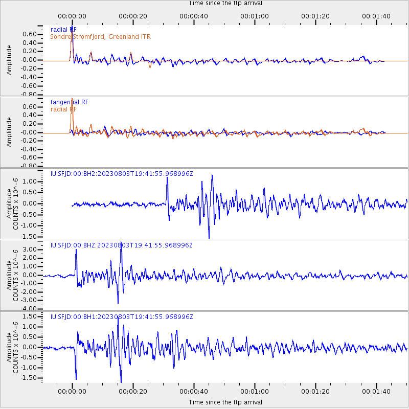
Signal To Noise
| Channel | StoN | STA | LTA |
| IU:SFJD:00:BHZ:20230803T19:41:55.968996Z | 19.855026 | 9.561306E-7 | 4.81556E-8 |
| IU:SFJD:00:BH1:20230803T19:41:55.968996Z | 9.921067 | 4.3452317E-7 | 4.379803E-8 |
| IU:SFJD:00:BH2:20230803T19:41:55.968996Z | 8.0794525 | 3.6843062E-7 | 4.560094E-8 |
| Arrivals |
| Ps | 6.1 SECOND |
| PpPs | 23 SECOND |
| PsPs/PpSs | 29 SECOND |


