You are here: Home > Network List > N4 - Central and EAstern US Network Stations List
> Station M44A Midewin, Midewin Nat. Tallgrass Prarie, IL, USA > Earthquake Result Viewer
M44A Midewin, Midewin Nat. Tallgrass Prarie, IL, USA - Earthquake Result Viewer
| Earthquake location: |
Alaska Peninsula |
| Earthquake latitude/longitude: |
54.7/-161.0 |
| Earthquake time(UTC): |
2023/08/03 (215) 19:33:51 GMT |
| Earthquake Depth: |
41 km |
| Earthquake Magnitude: |
5.6 mww |
| Earthquake Catalog/Contributor: |
NEIC PDE/us |
|
| Network: |
N4 Central and EAstern US Network |
| Station: |
M44A Midewin, Midewin Nat. Tallgrass Prarie, IL, USA |
| Lat/Lon: |
41.39 N/88.04 W |
| Elevation: |
207 m |
|
| Distance: |
48.4 deg |
| Az: |
74.205 deg |
| Baz: |
312.016 deg |
| Ray Param: |
0.06929588 |
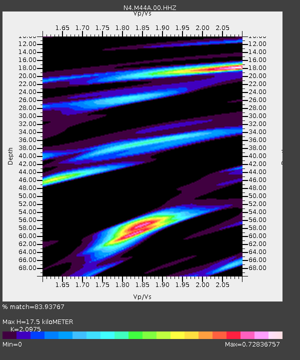
| Estimated Moho Depth: |
17.5 km |
| Estimated Crust Vp/Vs: |
2.10 |
| Assumed Crust Vp: |
6.498 km/s |
| Estimated Crust Vs: |
3.098 km/s |
| Estimated Crust Poisson's Ratio: |
0.35 |
|
| Radial Match: |
83.93767 % |
| Radial Bump: |
400 |
| Transverse Match: |
69.884895 % |
| Transverse Bump: |
400 |
| SOD ConfigId: |
31937991 |
| Insert Time: |
2023-08-17 19:50:25.922 +0000 |
| GWidth: |
2.5 |
| Max Bumps: |
400 |
| Tol: |
0.001 |
|

Signal To Noise
| Channel | StoN | STA | LTA |
| N4:M44A:00:HHZ:20230803T19:41:58.789003Z | 6.7802787 | 4.9318726E-7 | 7.27385E-8 |
| N4:M44A:00:HH1:20230803T19:41:58.789003Z | 2.5889251 | 1.3061478E-7 | 5.045136E-8 |
| N4:M44A:00:HH2:20230803T19:41:58.789003Z | 4.1491313 | 2.063979E-7 | 4.974485E-8 |
| Arrivals |
| Ps | 3.1 SECOND |
| PpPs | 7.9 SECOND |
| PsPs/PpSs | 11 SECOND |


