You are here: Home > Network List > N4 - Central and EAstern US Network Stations List
> Station S44A Carbondale, IL, USA > Earthquake Result Viewer
S44A Carbondale, IL, USA - Earthquake Result Viewer
| Earthquake location: |
Alaska Peninsula |
| Earthquake latitude/longitude: |
54.7/-161.0 |
| Earthquake time(UTC): |
2023/08/03 (215) 19:33:51 GMT |
| Earthquake Depth: |
41 km |
| Earthquake Magnitude: |
5.6 mww |
| Earthquake Catalog/Contributor: |
NEIC PDE/us |
|
| Network: |
N4 Central and EAstern US Network |
| Station: |
S44A Carbondale, IL, USA |
| Lat/Lon: |
37.69 N/89.26 W |
| Elevation: |
155 m |
|
| Distance: |
50.2 deg |
| Az: |
78.604 deg |
| Baz: |
314.115 deg |
| Ray Param: |
0.06809771 |
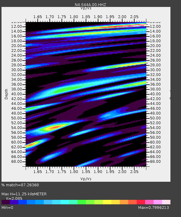
| Estimated Moho Depth: |
11.25 km |
| Estimated Crust Vp/Vs: |
2.09 |
| Assumed Crust Vp: |
6.444 km/s |
| Estimated Crust Vs: |
3.091 km/s |
| Estimated Crust Poisson's Ratio: |
0.35 |
|
| Radial Match: |
87.26368 % |
| Radial Bump: |
400 |
| Transverse Match: |
74.46722 % |
| Transverse Bump: |
400 |
| SOD ConfigId: |
31937991 |
| Insert Time: |
2023-08-17 19:51:19.556 +0000 |
| GWidth: |
2.5 |
| Max Bumps: |
400 |
| Tol: |
0.001 |
|

Signal To Noise
| Channel | StoN | STA | LTA |
| N4:S44A:00:HHZ:20230803T19:42:12.780Z | 4.975862 | 3.217472E-7 | 6.46616E-8 |
| N4:S44A:00:HH1:20230803T19:42:12.780Z | 3.01206 | 1.6575214E-7 | 5.5029496E-8 |
| N4:S44A:00:HH2:20230803T19:42:12.780Z | 2.7986236 | 1.6891022E-7 | 6.035475E-8 |
| Arrivals |
| Ps | 2.0 SECOND |
| PpPs | 5.1 SECOND |
| PsPs/PpSs | 7.1 SECOND |


