You are here: Home > Network List > N4 - Central and EAstern US Network Stations List
> Station T47A Sharon Grove, KY, USA > Earthquake Result Viewer
T47A Sharon Grove, KY, USA - Earthquake Result Viewer
| Earthquake location: |
Alaska Peninsula |
| Earthquake latitude/longitude: |
54.7/-161.0 |
| Earthquake time(UTC): |
2023/08/03 (215) 19:33:51 GMT |
| Earthquake Depth: |
41 km |
| Earthquake Magnitude: |
5.6 mww |
| Earthquake Catalog/Contributor: |
NEIC PDE/us |
|
| Network: |
N4 Central and EAstern US Network |
| Station: |
T47A Sharon Grove, KY, USA |
| Lat/Lon: |
36.99 N/87.11 W |
| Elevation: |
217 m |
|
| Distance: |
51.9 deg |
| Az: |
77.707 deg |
| Baz: |
314.85 deg |
| Ray Param: |
0.06698276 |
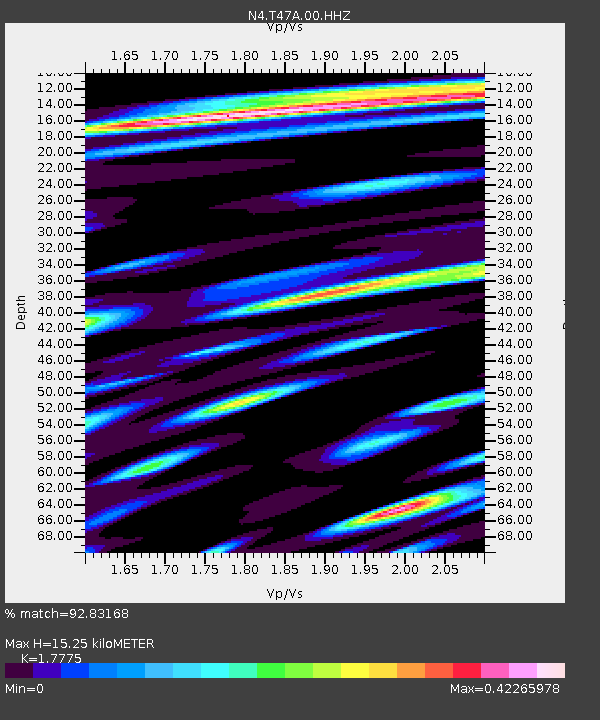
| Estimated Moho Depth: |
15.25 km |
| Estimated Crust Vp/Vs: |
1.78 |
| Assumed Crust Vp: |
6.444 km/s |
| Estimated Crust Vs: |
3.625 km/s |
| Estimated Crust Poisson's Ratio: |
0.27 |
|
| Radial Match: |
92.83168 % |
| Radial Bump: |
370 |
| Transverse Match: |
79.66073 % |
| Transverse Bump: |
400 |
| SOD ConfigId: |
31937991 |
| Insert Time: |
2023-08-17 19:51:34.280 +0000 |
| GWidth: |
2.5 |
| Max Bumps: |
400 |
| Tol: |
0.001 |
|

Signal To Noise
| Channel | StoN | STA | LTA |
| N4:T47A:00:HHZ:20230803T19:42:25.629Z | 8.916598 | 4.440049E-7 | 4.9795325E-8 |
| N4:T47A:00:HH1:20230803T19:42:25.629Z | 5.4912252 | 1.11411104E-7 | 2.0288933E-8 |
| N4:T47A:00:HH2:20230803T19:42:25.629Z | 4.298822 | 1.6863434E-7 | 3.9228038E-8 |
| Arrivals |
| Ps | 1.9 SECOND |
| PpPs | 6.2 SECOND |
| PsPs/PpSs | 8.2 SECOND |


