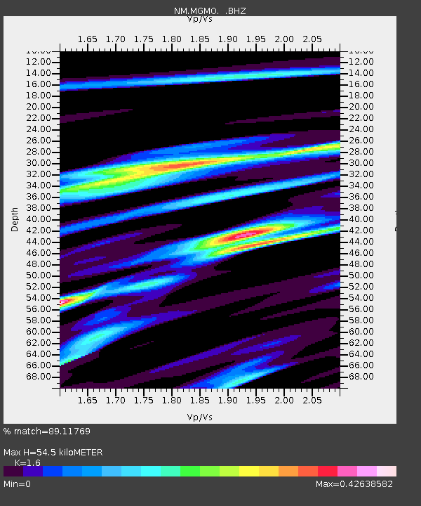
MGMO Mountain Grove, MO - Earthquake Result Viewer

Earthquake location: Near East Coast Of Honshu, Japan
Earthquake latitude/longitude: 39.7/142.4
Earthquake time(UTC): 2010/07/04 (185) 21:55:51 GMT
Earthquake Depth: 27 km
Earthquake Magnitude: 6.4 MB, 6.1 MS, 6.3 MW, 6.2 MW
Earthquake Catalog/Contributor: WHDF/NEIC
Network: NM Cooperative New Madrid Seismic Network
Station: MGMO Mountain Grove, MO
Lat/Lon: 37.15 N/92.27 W
Elevation: 453 m
Distance: 88.5 deg
Az: 40.676 deg
Baz: 320.994 deg
Ray Param: 0.042495355
Estimated Moho Depth: 54.5 km
Estimated Crust Vp/Vs: 1.60
Assumed Crust Vp: 6.53 km/s
Estimated Crust Vs: 4.082 km/s
Estimated Crust Poisson's Ratio: 0.18
Radial Match: 89.11769 %
Radial Bump: 348
Transverse Match: 73.76584 %
Transverse Bump: 400
SOD ConfigId: 319893
Insert Time: 2011-01-05 00:09:13.739 +0000
GWidth: 2.5
Max Bumps: 400
Tol: 0.001

Signal To Noise

ChannelStoNSTALTA
NM:MGMO: :BHZ:20100704T22:08:10.620015Z14.7334269.754264E-76.6205E-8
NM:MGMO: :BHN:20100704T22:08:10.620015Z4.31721643.0240273E-77.0045765E-8
NM:MGMO: :BHE:20100704T22:08:10.620015Z3.50683832.2779408E-76.4957106E-8
Arrivals
Ps5.1 SECOND
PpPs21 SECOND
PsPs/PpSs26 SECOND