You are here: Home > Network List > WY - Yellowstone Wyoming Seismic Network Stations List
> Station YHH Holmes Hill, YNP, WY, USA > Earthquake Result Viewer
YHH Holmes Hill, YNP, WY, USA - Earthquake Result Viewer
*The percent match for this event was below the threshold and hence no stack was calculated.
| Earthquake location: |
Southeast Of Loyalty Islands |
| Earthquake latitude/longitude: |
-21.9/169.5 |
| Earthquake time(UTC): |
2018/12/05 (339) 04:31:23 GMT |
| Earthquake Depth: |
10 km |
| Earthquake Magnitude: |
5.6 mb |
| Earthquake Catalog/Contributor: |
NEIC PDE/us |
|
| Network: |
WY Yellowstone Wyoming Seismic Network |
| Station: |
YHH Holmes Hill, YNP, WY, USA |
| Lat/Lon: |
44.79 N/110.85 W |
| Elevation: |
2717 m |
|
| Distance: |
98.1 deg |
| Az: |
45.028 deg |
| Baz: |
247.338 deg |
| Ray Param: |
$rayparam |
*The percent match for this event was below the threshold and hence was not used in the summary stack. |
|
| Radial Match: |
26.838121 % |
| Radial Bump: |
239 |
| Transverse Match: |
35.927578 % |
| Transverse Bump: |
208 |
| SOD ConfigId: |
3201911 |
| Insert Time: |
2018-12-19 04:37:36.431 +0000 |
| GWidth: |
2.5 |
| Max Bumps: |
400 |
| Tol: |
0.001 |
|
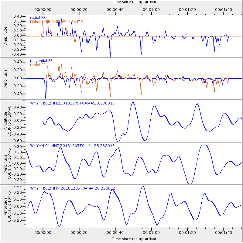
Signal To Noise
| Channel | StoN | STA | LTA |
| WY:YHH:01:HHZ:20181205T04:44:28.23801Z | 1.1868123 | 1.1756818E-7 | 9.906214E-8 |
| WY:YHH:01:HHN:20181205T04:44:28.23801Z | 3.4857304 | 2.0212289E-7 | 5.7985805E-8 |
| WY:YHH:01:HHE:20181205T04:44:28.23801Z | 1.9447048 | 2.8309447E-7 | 1.4557195E-7 |
| Arrivals |
| Ps | |
| PpPs | |
| PsPs/PpSs | |


