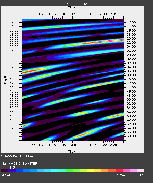
GKP GORKA KLASZTORNA, POLAND - Earthquake Result Viewer

Earthquake location: Near East Coast Of Honshu, Japan
Earthquake latitude/longitude: 39.7/142.4
Earthquake time(UTC): 2010/07/04 (185) 21:55:51 GMT
Earthquake Depth: 27 km
Earthquake Magnitude: 6.4 MB, 6.1 MS, 6.3 MW, 6.2 MW
Earthquake Catalog/Contributor: WHDF/NEIC
Network: PL Polish Seismological Network
Station: GKP GORKA KLASZTORNA, POLAND
Lat/Lon: 53.27 N/17.24 E
Elevation: 115 m
Distance: 76.0 deg
Az: 329.585 deg
Baz: 40.565 deg
Ray Param: 0.05125716
Estimated Moho Depth: 63.0 km
Estimated Crust Vp/Vs: 1.60
Assumed Crust Vp: 6.234 km/s
Estimated Crust Vs: 3.896 km/s
Estimated Crust Poisson's Ratio: 0.18
Radial Match: 84.99364 %
Radial Bump: 400
Transverse Match: 84.909195 %
Transverse Bump: 400
SOD ConfigId: 319893
Insert Time: 2011-01-05 00:10:00.468 +0000
GWidth: 2.5
Max Bumps: 400
Tol: 0.001

Signal To Noise

ChannelStoNSTALTA
PL:GKP: :BHZ:20100704T22:07:05.428975Z28.6034343.283101E-61.14779965E-7
PL:GKP: :BHN:20100704T22:07:05.428975Z4.371728.368731E-71.914288E-7
PL:GKP: :BHE:20100704T22:07:05.428975Z1.19241242.0062913E-71.6825483E-7
Arrivals
Ps6.3 SECOND
PpPs25 SECOND
PsPs/PpSs32 SECOND