You are here: Home > Network List > TA - USArray Transportable Network (new EarthScope stations) Stations List
> Station 121A Cookes Peak, Deming, NM, USA > Earthquake Result Viewer
121A Cookes Peak, Deming, NM, USA - Earthquake Result Viewer
| Earthquake location: |
Near East Coast Of Honshu, Japan |
| Earthquake latitude/longitude: |
39.7/142.4 |
| Earthquake time(UTC): |
2010/07/04 (185) 21:55:51 GMT |
| Earthquake Depth: |
27 km |
| Earthquake Magnitude: |
6.4 MB, 6.1 MS, 6.3 MW, 6.2 MW |
| Earthquake Catalog/Contributor: |
WHDF/NEIC |
|
| Network: |
TA USArray Transportable Network (new EarthScope stations) |
| Station: |
121A Cookes Peak, Deming, NM, USA |
| Lat/Lon: |
32.53 N/107.79 W |
| Elevation: |
1652 m |
|
| Distance: |
83.2 deg |
| Az: |
53.155 deg |
| Baz: |
313.036 deg |
| Ray Param: |
0.04635963 |
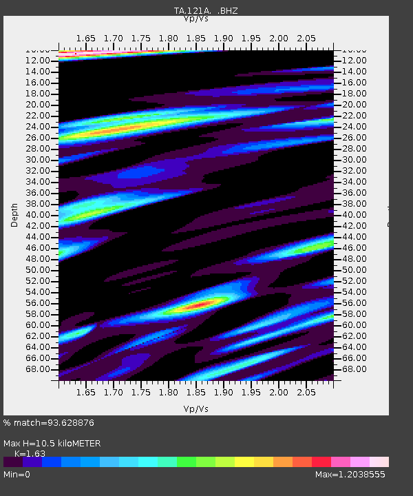
| Estimated Moho Depth: |
10.5 km |
| Estimated Crust Vp/Vs: |
1.63 |
| Assumed Crust Vp: |
6.502 km/s |
| Estimated Crust Vs: |
3.989 km/s |
| Estimated Crust Poisson's Ratio: |
0.20 |
|
| Radial Match: |
93.628876 % |
| Radial Bump: |
400 |
| Transverse Match: |
76.823204 % |
| Transverse Bump: |
400 |
| SOD ConfigId: |
319893 |
| Insert Time: |
2011-01-05 00:10:58.998 +0000 |
| GWidth: |
2.5 |
| Max Bumps: |
400 |
| Tol: |
0.001 |
|
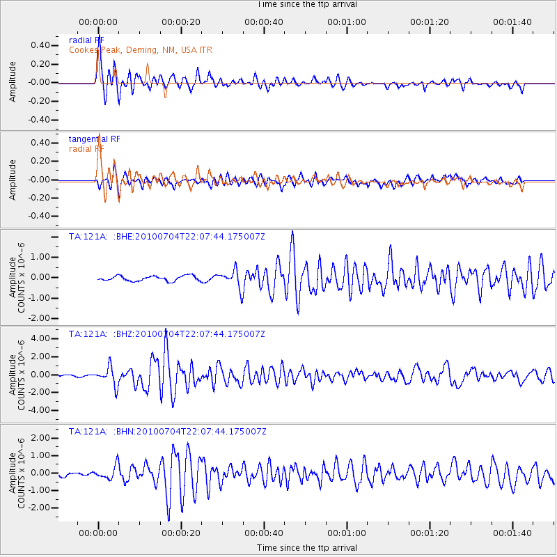
Signal To Noise
| Channel | StoN | STA | LTA |
| TA:121A: :BHZ:20100704T22:07:44.175007Z | 10.147435 | 1.0452599E-6 | 1.030073E-7 |
| TA:121A: :BHN:20100704T22:07:44.175007Z | 3.6033523 | 3.9816663E-7 | 1.10498945E-7 |
| TA:121A: :BHE:20100704T22:07:44.175007Z | 3.7216933 | 4.6156876E-7 | 1.2402117E-7 |
| Arrivals |
| Ps | 1.0 SECOND |
| PpPs | 4.1 SECOND |
| PsPs/PpSs | 5.2 SECOND |


