You are here: Home > Network List > UU - University of Utah Regional Network Stations List
> Station FSB4 FORGE surface borehole 4, UT, USA > Earthquake Result Viewer
FSB4 FORGE surface borehole 4, UT, USA - Earthquake Result Viewer
| Earthquake location: |
Alaska Peninsula |
| Earthquake latitude/longitude: |
54.7/-161.0 |
| Earthquake time(UTC): |
2023/08/03 (215) 19:33:51 GMT |
| Earthquake Depth: |
41 km |
| Earthquake Magnitude: |
5.6 mww |
| Earthquake Catalog/Contributor: |
NEIC PDE/us |
|
| Network: |
UU University of Utah Regional Network |
| Station: |
FSB4 FORGE surface borehole 4, UT, USA |
| Lat/Lon: |
38.43 N/112.93 W |
| Elevation: |
1578 m |
|
| Distance: |
36.1 deg |
| Az: |
96.568 deg |
| Baz: |
312.708 deg |
| Ray Param: |
0.07682747 |
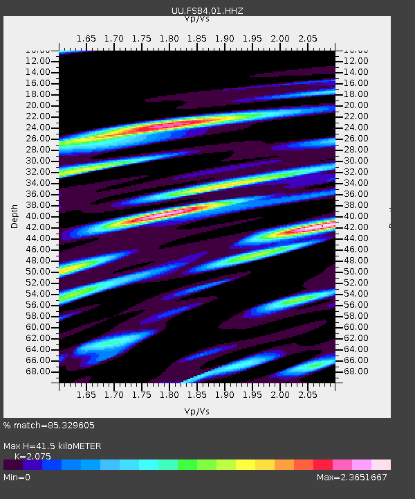
| Estimated Moho Depth: |
41.5 km |
| Estimated Crust Vp/Vs: |
2.08 |
| Assumed Crust Vp: |
6.276 km/s |
| Estimated Crust Vs: |
3.024 km/s |
| Estimated Crust Poisson's Ratio: |
0.35 |
|
| Radial Match: |
85.329605 % |
| Radial Bump: |
400 |
| Transverse Match: |
59.51754 % |
| Transverse Bump: |
400 |
| SOD ConfigId: |
31937991 |
| Insert Time: |
2023-08-17 20:02:15.197 +0000 |
| GWidth: |
2.5 |
| Max Bumps: |
400 |
| Tol: |
0.001 |
|

Signal To Noise
| Channel | StoN | STA | LTA |
| UU:FSB4:01:HHZ:20230803T19:40:18.500002Z | 2.3228302 | 2.2167588E-7 | 9.543353E-8 |
| UU:FSB4:01:HH1:20230803T19:40:18.500002Z | 1.1514405 | 1.9039487E-7 | 1.6535364E-7 |
| UU:FSB4:01:HH2:20230803T19:40:18.500002Z | 1.7043626 | 1.7473758E-7 | 1.0252371E-7 |
| Arrivals |
| Ps | 7.6 SECOND |
| PpPs | 19 SECOND |
| PsPs/PpSs | 27 SECOND |


