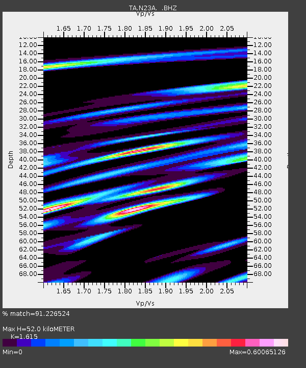
N23A Red Feather Lakes, CO, USA - Earthquake Result Viewer

Earthquake location: Near East Coast Of Honshu, Japan
Earthquake latitude/longitude: 39.7/142.4
Earthquake time(UTC): 2010/07/04 (185) 21:55:51 GMT
Earthquake Depth: 27 km
Earthquake Magnitude: 6.4 MB, 6.1 MS, 6.3 MW, 6.2 MW
Earthquake Catalog/Contributor: WHDF/NEIC
Network: TA USArray Transportable Network (new EarthScope stations)
Station: N23A Red Feather Lakes, CO, USA
Lat/Lon: 40.89 N/105.94 W
Elevation: 2458 m
Distance: 78.5 deg
Az: 45.953 deg
Baz: 312.986 deg
Ray Param: 0.049541682
Estimated Moho Depth: 52.0 km
Estimated Crust Vp/Vs: 1.62
Assumed Crust Vp: 6.306 km/s
Estimated Crust Vs: 3.905 km/s
Estimated Crust Poisson's Ratio: 0.19
Radial Match: 91.226524 %
Radial Bump: 400
Transverse Match: 82.193344 %
Transverse Bump: 400
SOD ConfigId: 319893
Insert Time: 2011-01-05 00:11:31.909 +0000
GWidth: 2.5
Max Bumps: 400
Tol: 0.001

Signal To Noise

ChannelStoNSTALTA
TA:N23A: :BHZ:20100704T22:07:19.599995Z21.2344151.5967977E-67.519857E-8
TA:N23A: :BHN:20100704T22:07:19.599995Z3.99325664.2324064E-71.0598884E-7
TA:N23A: :BHE:20100704T22:07:19.599995Z2.41404346.282611E-72.6025262E-7
Arrivals
Ps5.2 SECOND
PpPs21 SECOND
PsPs/PpSs26 SECOND