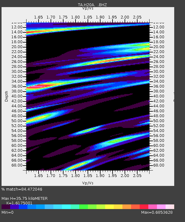
H20A Greybull, WY, USA - Earthquake Result Viewer
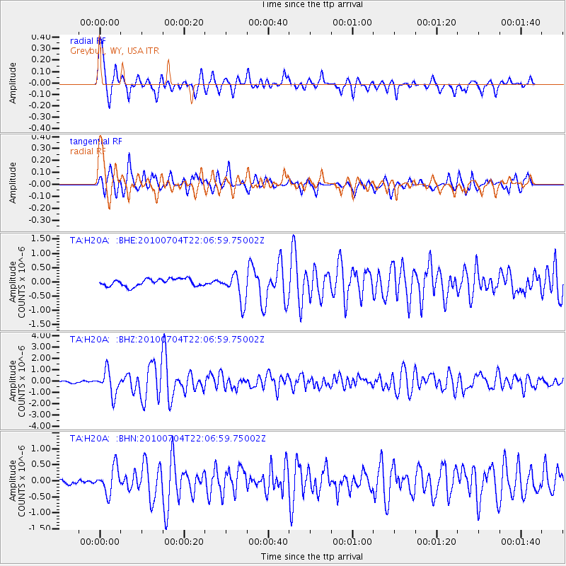
Earthquake location: Near East Coast Of Honshu, Japan
Earthquake latitude/longitude: 39.7/142.4
Earthquake time(UTC): 2010/07/04 (185) 21:55:51 GMT
Earthquake Depth: 27 km
Earthquake Magnitude: 6.4 MB, 6.1 MS, 6.3 MW, 6.2 MW
Earthquake Catalog/Contributor: WHDF/NEIC
Network: TA USArray Transportable Network (new EarthScope stations)
Station: H20A Greybull, WY, USA
Lat/Lon: 44.49 N/108.00 W
Elevation: 1236 m
Distance: 75.0 deg
Az: 44.26 deg
Baz: 311.21 deg
Ray Param: 0.05192066
Estimated Moho Depth: 35.75 km
Estimated Crust Vp/Vs: 1.62
Assumed Crust Vp: 6.178 km/s
Estimated Crust Vs: 3.82 km/s
Estimated Crust Poisson's Ratio: 0.19
Radial Match: 84.472046 %
Radial Bump: 400
Transverse Match: 79.57943 %
Transverse Bump: 400
SOD ConfigId: 319893
Insert Time: 2011-01-05 00:11:57.990 +0000
GWidth: 2.5
Max Bumps: 400
Tol: 0.001

Signal To Noise

ChannelStoNSTALTA
TA:H20A: :BHZ:20100704T22:06:59.75002Z15.1814811.068709E-67.0395565E-8
TA:H20A: :BHN:20100704T22:06:59.75002Z4.69569734.1827218E-78.907563E-8
TA:H20A: :BHE:20100704T22:06:59.75002Z4.1344415.235241E-71.2662511E-7
Arrivals
Ps3.7 SECOND
PpPs15 SECOND
PsPs/PpSs18 SECOND