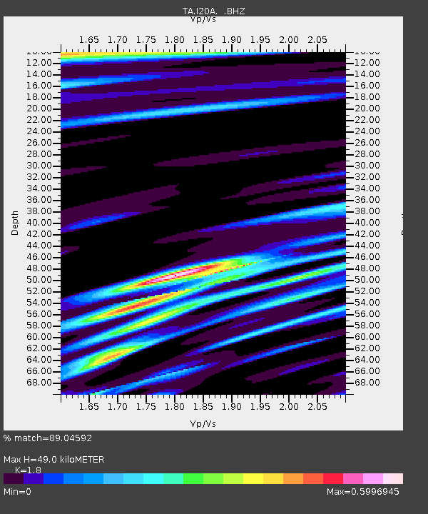
I20A Worland, WY, USA - Earthquake Result Viewer
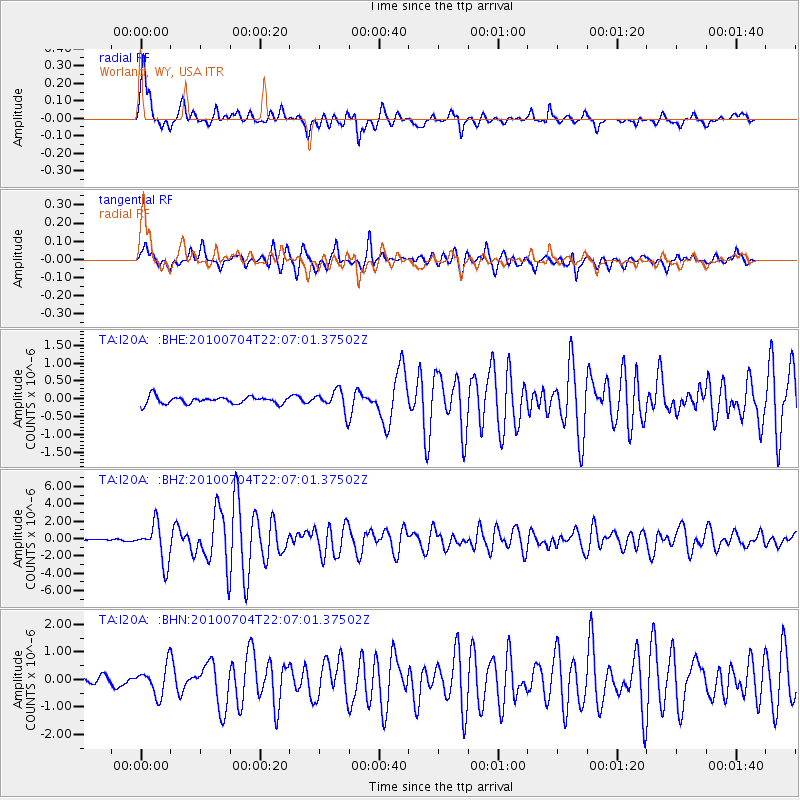
Earthquake location: Near East Coast Of Honshu, Japan
Earthquake latitude/longitude: 39.7/142.4
Earthquake time(UTC): 2010/07/04 (185) 21:55:51 GMT
Earthquake Depth: 27 km
Earthquake Magnitude: 6.4 MB, 6.1 MS, 6.3 MW, 6.2 MW
Earthquake Catalog/Contributor: WHDF/NEIC
Network: TA USArray Transportable Network (new EarthScope stations)
Station: I20A Worland, WY, USA
Lat/Lon: 43.95 N/108.13 W
Elevation: 1342 m
Distance: 75.3 deg
Az: 44.742 deg
Baz: 311.243 deg
Ray Param: 0.051735487
Estimated Moho Depth: 49.0 km
Estimated Crust Vp/Vs: 1.80
Assumed Crust Vp: 6.161 km/s
Estimated Crust Vs: 3.423 km/s
Estimated Crust Poisson's Ratio: 0.28
Radial Match: 89.04592 %
Radial Bump: 400
Transverse Match: 88.333984 %
Transverse Bump: 400
SOD ConfigId: 319893
Insert Time: 2011-01-05 00:12:08.473 +0000
GWidth: 2.5
Max Bumps: 400
Tol: 0.001

Signal To Noise

ChannelStoNSTALTA
TA:I20A: :BHZ:20100704T22:07:01.37502Z20.132682.1816902E-61.08365604E-7
TA:I20A: :BHN:20100704T22:07:01.37502Z3.71966725.3149137E-71.428868E-7
TA:I20A: :BHE:20100704T22:07:01.37502Z2.89503032.9298576E-71.01203E-7
Arrivals
Ps6.6 SECOND
PpPs22 SECOND
PsPs/PpSs28 SECOND