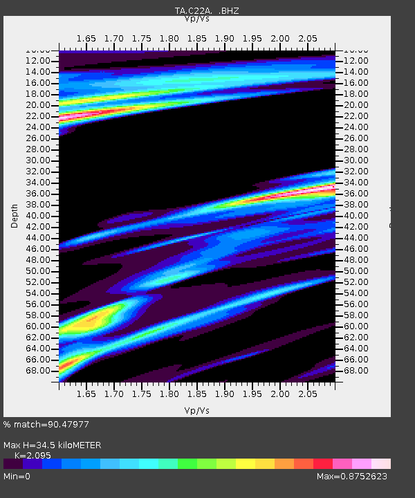
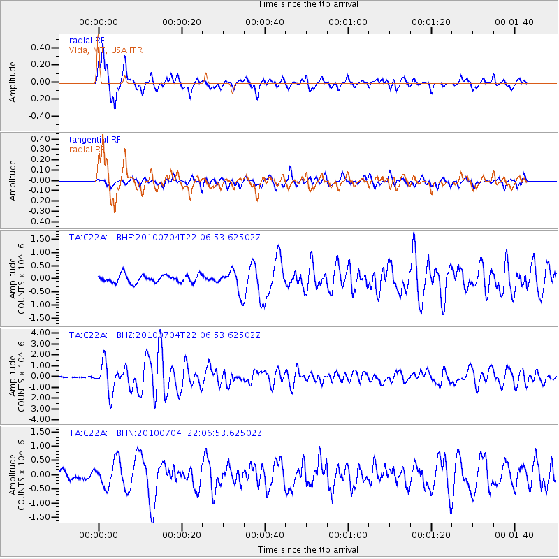
C22A Vida, MT, USA - Earthquake Result Viewer

Earthquake location: Near East Coast Of Honshu, Japan
Earthquake latitude/longitude: 39.7/142.4
Earthquake time(UTC): 2010/07/04 (185) 21:55:51 GMT
Earthquake Depth: 27 km
Earthquake Magnitude: 6.4 MB, 6.1 MS, 6.3 MW, 6.2 MW
Earthquake Catalog/Contributor: WHDF/NEIC
Network: TA USArray Transportable Network (new EarthScope stations)
Station: C22A Vida, MT, USA
Lat/Lon: 47.75 N/105.88 W
Elevation: 745 m
Distance: 73.9 deg
Az: 40.715 deg
Baz: 311.78 deg
Ray Param: 0.05262854
Estimated Moho Depth: 34.5 km
Estimated Crust Vp/Vs: 2.10
Assumed Crust Vp: 6.438 km/s
Estimated Crust Vs: 3.073 km/s
Estimated Crust Poisson's Ratio: 0.35
Radial Match: 90.47977 %
Radial Bump: 358
Transverse Match: 71.51613 %
Transverse Bump: 400
SOD ConfigId: 319893
Insert Time: 2011-01-05 00:13:23.145 +0000
GWidth: 2.5
Max Bumps: 400
Tol: 0.001

Signal To Noise

ChannelStoNSTALTA
TA:C22A: :BHZ:20100704T22:06:53.62502Z25.4173371.3908301E-65.471974E-8
TA:C22A: :BHN:20100704T22:06:53.62502Z3.12009454.609768E-71.4774449E-7
TA:C22A: :BHE:20100704T22:06:53.62502Z3.07222774.4060886E-71.4341674E-7
Arrivals
Ps6.0 SECOND
PpPs16 SECOND
PsPs/PpSs22 SECOND